Villeneuve-la-Dondagre
Villeneuve-la-Dondagre ist eine französische Gemeinde mit 318 Einwohnern (Stand 1. Januar 2019) im Département Yonne in der Region Bourgogne-Franche-Comté (vor 2016 Bourgogne). Villeneuve-la-Dondagre gehört zum Arrondissement Sens und zum Kanton Gâtinais en Bourgogne (bis 2015 Chéroy).
| Villeneuve-la-Dondagre | ||
|---|---|---|
| ||
| Staat | Frankreich | |
| Region | Bourgogne-Franche-Comté | |
| Département (Nr.) | Yonne (89) | |
| Arrondissement | Sens | |
| Kanton | Gâtinais en Bourgogne | |
| Gemeindeverband | Gâtinais en Bourgogne | |
| Koordinaten | 48° 8′ N, 3° 8′ O | |
| Höhe | 161–201 m | |
| Fläche | 14,56 km² | |
| Einwohner | 318 (1. Januar 2019) | |
| Bevölkerungsdichte | 22 Einw./km² | |
| Postleitzahl | 89150 | |
| INSEE-Code | 89459 | |
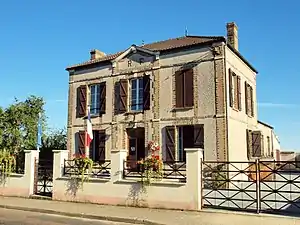 Rathaus von Villeneuve-la-Dondagre | ||

Geographie
Villeneuve-la-Dondagre liegt etwa 14 Kilometer westsüdwestlich des Stadtzentrums von Sens. Umgeben wird Villeneuve-la-Dondagre von den Nachbargemeinden Fouchères im Norden, Subligny und Collemiers im Nordosten, Cornant im Osten, Égriselles-le-Bocage im Südosten, Courtoin im Süden, La Belliole im Westen sowie Saint-Valérien im Nordwesten.
Durch die Gemeinde führt die Autoroute A19.
Bevölkerungsentwicklung
| Jahr | 1881 | 1962 | 1968 | 1975 | 1982 | 1990 | 1999 | 2006 | 2013 |
| Einwohner | 377 | 192 | 189 | 180 | 160 | 170 | 204 | 224 | 273 |
| Quellen: Cassini und INSEE | |||||||||
Sehenswürdigkeiten
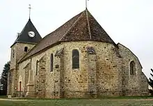
Kirche Saint-Loup
- Kirche Saint-Loup
- Schloss
Weblinks
Commons: Villeneuve-la-Dondagre – Sammlung von Bildern, Videos und Audiodateien
This article is issued from Wikipedia. The text is licensed under Creative Commons - Attribution - Sharealike. The authors of the article are listed here. Additional terms may apply for the media files, click on images to show image meta data.