La Postolle
La Postolle ist eine französische Gemeinde mit 140 Einwohnern (Stand: 1. Januar 2019) im Département Yonne in der Region Bourgogne-Franche-Comté (vor 2016 Bourgogne). Sie ist Teil des Kantons Brienon-sur-Armançon (bis 2015: Kanton Villeneuve-l’Archevêque). Die Einwohner werden Postolliers genannt.
| La Postolle | ||
|---|---|---|
| ||
| Staat | Frankreich | |
| Region | Bourgogne-Franche-Comté | |
| Département (Nr.) | Yonne (89) | |
| Arrondissement | Sens | |
| Kanton | Brienon-sur-Armançon | |
| Gemeindeverband | Vanne et du Pays d’Othe | |
| Koordinaten | 48° 17′ N, 3° 27′ O | |
| Höhe | 123–227 m | |
| Fläche | 11,60 km² | |
| Einwohner | 140 (1. Januar 2019) | |
| Bevölkerungsdichte | 12 Einw./km² | |
| Postleitzahl | 89260 | |
| INSEE-Code | 89310 | |
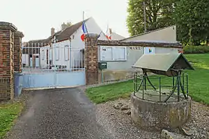 Rathaus (Mairie) von La Postolle | ||

Geografie
La Postolle liegt etwa 20 Kilometer nordöstlich von Sens und etwa 56 Kilometer westlich von Troyes. Umgeben wird La Postolle von den Nachbargemeinden Perceneige im Norden, Saint-Maurice-aux-Riches-Hommes im Nordosten, Lailly im Osten und Südosten, Voisines im Süden und Südwesten sowie Thorigny-sur-Oreuse im Westen.
Bevölkerungsentwicklung
| Jahr | 1962 | 1968 | 1975 | 1982 | 1990 | 1999 | 2006 | 2013 |
|---|---|---|---|---|---|---|---|---|
| Einwohner | 162 | 135 | 117 | 109 | 118 | 136 | 154 | 140 |
| Quellen: Cassini und INSEE | ||||||||
Sehenswürdigkeiten
- Kirche Saint-Joseph-et-Saint-Fiacre
- Höhlenwohnungen
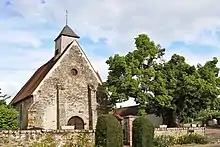
Kirche Saint-Joseph-et-Saint-Fiacre
Weblinks
Commons: La Postolle – Sammlung von Bildern, Videos und Audiodateien
This article is issued from Wikipedia. The text is licensed under Creative Commons - Attribution - Sharealike. The authors of the article are listed here. Additional terms may apply for the media files, click on images to show image meta data.