Soussac
Soussac ist eine französische Gemeinde mit 199 Einwohnern (Stand 1. Januar 2019) im Département Gironde in der Region Nouvelle-Aquitaine. Sie gehört zum Arrondissement Langon und zum Kanton Le Réolais et Les Bastides (bis 2015 Kanton Pellegrue).
| Soussac | ||
|---|---|---|
| ||
| Staat | Frankreich | |
| Region | Nouvelle-Aquitaine | |
| Département (Nr.) | Gironde (33) | |
| Arrondissement | Langon | |
| Kanton | Le Réolais et Les Bastides | |
| Gemeindeverband | Rurales de l’Entre-Deux-Mers | |
| Koordinaten | 44° 44′ N, 1° 8′ O | |
| Höhe | 63–125 m | |
| Fläche | 6,62 km² | |
| Einwohner | 199 (1. Januar 2019) | |
| Bevölkerungsdichte | 30 Einw./km² | |
| Postleitzahl | 33790 | |
| INSEE-Code | 33516 | |
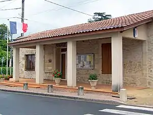 Mairie Soussac | ||

Geografie und Infrastruktur
Die Gemeinde grenzt im Norden an Saint-Antoine-du-Queyret, im Nordosten an Listrac-de-Durèze, im Osten an Auriolles, im Süden an Cazaugitat und im Westen an Mauriac.
Die vormalige Route nationale 672 führt über Soussac. Sie wurde zu einer Départementsstraße abgestuft.
Bevölkerungsentwicklung
| Jahr | 1962 | 1968 | 1975 | 1982 | 1990 | 1999 | 2008 | 2017 |
|---|---|---|---|---|---|---|---|---|
| Einwohner | 285 | 260 | 221 | 230 | 195 | 159 | 182 | 190 |
Sehenswürdigkeiten
- Kirche Saint-Hilaire (siehe auch: Liste der Monuments historiques in Soussac)
- Taubenturm
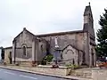 Kirche Saint-Hilaire
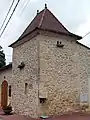 Taubenturm
Literatur
- Le Patrimoine des Communes de la Gironde. Flohic Éditions, Band 2, Paris 2001, ISBN 2-84234-125-2, S. 1084–1088.
Weblinks
Commons: Soussac – Sammlung von Bildern, Videos und Audiodateien
This article is issued from Wikipedia. The text is licensed under Creative Commons - Attribution - Sharealike. The authors of the article are listed here. Additional terms may apply for the media files, click on images to show image meta data.