Brannens
Brannens (okzitanisch Branens) ist eine französische Gemeinde mit 241 Einwohnern (Stand: 1. Januar 2019) im Département Gironde in der Region Nouvelle-Aquitaine. Sie gehört zum Arrondissement Langon und zum Kanton Le Réolais et Les Bastides. Die Einwohner werden Brannensois genannt.
| Brannens Branens | ||
|---|---|---|
| ||
| Staat | Frankreich | |
| Region | Nouvelle-Aquitaine | |
| Département (Nr.) | Gironde (33) | |
| Arrondissement | Langon | |
| Kanton | Le Réolais et Les Bastides | |
| Gemeindeverband | Réolais en Sud Gironde | |
| Koordinaten | 44° 31′ N, 0° 9′ W | |
| Höhe | 15–65 m | |
| Fläche | 6,06 km² | |
| Einwohner | 241 (1. Januar 2019) | |
| Bevölkerungsdichte | 40 Einw./km² | |
| Postleitzahl | 33124 | |
| INSEE-Code | 33072 | |
| Website | http://brannens33.fr/ | |
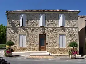 Rathaus (Mairie) von Brannens | ||

Geographie
Brannens liegt etwa 56 Kilometer ostsüdöstlich von Bordeaux. Umgeben wird Brannens von den Nachbargemeinden Bieujac im Norden, Savignac im Osten sowie Auros im Süden und Westen.
Bevölkerungsentwicklung
| 1962 | 1968 | 1975 | 1982 | 1990 | 1999 | 2006 | 2013 |
|---|---|---|---|---|---|---|---|
| 205 | 178 | 162 | 176 | 193 | 173 | 212 | 221 |
| Quelle: cassini und INSEE | |||||||
Literatur
- Le Patrimoine des Communes de la Gironde. Flohic Éditions, Band 1, Paris 2001, ISBN 2-84234-125-2, S. 98–99.
Weblinks
Commons: Brannens – Sammlung von Bildern, Videos und Audiodateien
This article is issued from Wikipedia. The text is licensed under Creative Commons - Attribution - Sharealike. The authors of the article are listed here. Additional terms may apply for the media files, click on images to show image meta data.