Cleyrac
Cleyrac (okzitanisch Clairac) ist eine französische Gemeinde mit 155 Einwohnern (Stand: 1. Januar 2019) im Département Gironde in der Region Nouvelle-Aquitaine. Sie gehört zum Arrondissement Langon und zum Kanton Le Réolais et Les Bastides. Die Einwohner werden Cleyracais genannt.
| Cleyrac Clairac | ||
|---|---|---|
| ||
| Staat | Frankreich | |
| Region | Nouvelle-Aquitaine | |
| Département (Nr.) | Gironde (33) | |
| Arrondissement | Langon | |
| Kanton | Le Réolais et Les Bastides | |
| Gemeindeverband | Rurales de l’Entre-Deux-Mers | |
| Koordinaten | 44° 43′ N, 0° 2′ W | |
| Höhe | 53–106 m | |
| Fläche | 6,10 km² | |
| Einwohner | 155 (1. Januar 2019) | |
| Bevölkerungsdichte | 25 Einw./km² | |
| Postleitzahl | 33540 | |
| INSEE-Code | 33129 | |
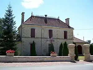 Rathaus (Mairie) von Cleyrac | ||

Geographie
Cleyrac liegt etwa 50 Kilometer ostsüdöstlich von Bordeaux. Umgeben wird Cleyrac von den Nachbargemeinden Mauriac im Norden und Nordosten, Cazaugitat im Osten, Caumont im Südosten, Sauveterre-de-Guyenne im Süden und Westen sowie Blasimon im Nordwesten.
Bevölkerungsentwicklung
| 1962 | 1968 | 1975 | 1982 | 1990 | 1999 | 2006 | 2017 |
|---|---|---|---|---|---|---|---|
| 184 | 156 | 142 | 124 | 143 | 149 | 144 | 160 |
| Quellen: cassini und INSEE | |||||||
Sehenswürdigkeiten
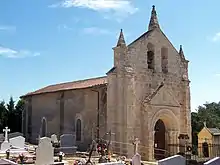
Kirche Saint-Pierre
- Kirche Saint-Pierre
- Schloss Basgéran aus dem 16./17. Jahrhundert, seit 1927 Monument historique
- Mühle La Salle aus dem 14. Jahrhundert, Monument historique seit 1927
Literatur
- Le Patrimoine des Communes de la Gironde. Flohic Éditions, Band 2, Paris 2001, ISBN 2-84234-125-2, S. 1475–1476.
Weblinks
Commons: Cleyrac – Sammlung von Bildern, Videos und Audiodateien
This article is issued from Wikipedia. The text is licensed under Creative Commons - Attribution - Sharealike. The authors of the article are listed here. Additional terms may apply for the media files, click on images to show image meta data.