Morizès
Morizès (gaskognisch: Maurisèth) ist eine Gemeinde mit 549 Einwohnern (Stand: 1. Januar 2019) im französischen Département Gironde. Sie gehört zum Kanton Le Réolais et Les Bastides im Arrondissement Langon. Die Einwohner werden Morizéens genannt.
| Morizès Maurisèth | ||
|---|---|---|
| ||
| Staat | Frankreich | |
| Region | Nouvelle-Aquitaine | |
| Département (Nr.) | Gironde (33) | |
| Arrondissement | Langon | |
| Kanton | Le Réolais et Les Bastides | |
| Gemeindeverband | Réolais en Sud Gironde | |
| Koordinaten | 44° 37′ N, 0° 5′ W | |
| Höhe | 10–77 m | |
| Fläche | 5,90 km² | |
| Einwohner | 549 (1. Januar 2019) | |
| Bevölkerungsdichte | 93 Einw./km² | |
| Postleitzahl | 33190 | |
| INSEE-Code | 33294 | |
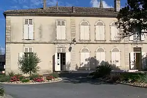 Rathaus (Mairie) von Morizès | ||

Geografie
Morizès liegt etwa 45 Kilometer südöstlich von Bordeaux am Dropt, der die Gemeinde im Osten begrenzt. Umgeben wird Morizès von den Nachbargemeinden Saint-Exupéry im Norden, Camiran im Nordosten, Les Esseintes im Osten, Gironde-sur-Dropt im Süden und Südosten, Casseuil im Süden und Südwesten, Sainte-Foy-la-Longue im Westen sowie Saint-Laurent-du-Plan im Nordwesten.
Bevölkerungsentwicklung
| Jahr | 1962 | 1968 | 1975 | 1982 | 1990 | 1999 | 2006 | 2017 |
|---|---|---|---|---|---|---|---|---|
| Einwohner | 534 | 542 | 514 | 508 | 505 | 507 | 549 | 545 |
| Quellen: Cassini und INSEE | ||||||||
Sehenswürdigkeiten
- Kirche Saint-Maurice aus dem 19. Jahrhundert
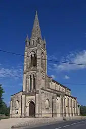
Kirche Saint-Maurice
Persönlichkeiten
- Jean Sourbet (1900–1962), Politiker, Landwirtschaftsminister (1955/1956)
Literatur
- Le Patrimoine des Communes de la Gironde. Flohic Éditions, Band 2, Paris 2001, ISBN 2-84234-125-2, S. 1224.
Weblinks
Commons: Morizès – Sammlung von Bildern, Videos und Audiodateien
This article is issued from Wikipedia. The text is licensed under Creative Commons - Attribution - Sharealike. The authors of the article are listed here. Additional terms may apply for the media files, click on images to show image meta data.