Le Puy (Gironde)
Le Puy (okzitanisch Lo Puèi) ist eine französische Gemeinde mit 407 Einwohnern (Stand: 1. Januar 2019) im Département Gironde in der Region Nouvelle-Aquitaine. Sie gehört zum Arrondissement Langon und zum Kanton Le Réolais et Les Bastides. Die Einwohner werden Podiens genannt.
| Le Puy Lo Puèi | ||
|---|---|---|
.svg.png.webp)
|
| |
| Staat | Frankreich | |
| Region | Nouvelle-Aquitaine | |
| Département (Nr.) | Gironde (33) | |
| Arrondissement | Langon | |
| Kanton | Le Réolais et Les Bastides | |
| Gemeindeverband | Rurales de l’Entre-Deux-Mers | |
| Koordinaten | 44° 40′ N, 0° 4′ W | |
| Höhe | 18–115 m | |
| Fläche | 8,54 km² | |
| Einwohner | 407 (1. Januar 2019) | |
| Bevölkerungsdichte | 48 Einw./km² | |
| Postleitzahl | 33580 | |
| INSEE-Code | 33345 | |
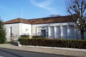 Rathaus (Mairie) von Le Puy | ||

Geographie
Le Puy liegt etwa 64 Kilometer ostsüdöstlich von Bordeaux. Der Dropt begrenzt die Gemeinde im Süden. Umgeben wird Le Puy von den Nachbargemeinden Saint-Ferme im Norden, Dieulivol im Osten und Nordosten, Monségur im Süden und Osten, Saint-Sulpice-de-Guilleragues im Süden und Südwesten sowie Coutures im Westen.
Bevölkerungsentwicklung
| 1962 | 1968 | 1975 | 1982 | 1990 | 1999 | 2006 | 2017 |
|---|---|---|---|---|---|---|---|
| 372 | 366 | 309 | 257 | 281 | 290 | 360 | 403 |
| Quellen: cassini und INSEE | |||||||
Sehenswürdigkeiten
- Kirche Sainte-Anne
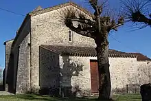
Kirche Sainte-Anne
Literatur
- Le Patrimoine des Communes de la Gironde. Flohic Éditions, Band 2, Paris 2001, ISBN 2-84234-125-2, S. 996–997.
Weblinks
Commons: Le Puy – Sammlung von Bildern, Videos und Audiodateien
This article is issued from Wikipedia. The text is licensed under Creative Commons - Attribution - Sharealike. The authors of the article are listed here. Additional terms may apply for the media files, click on images to show image meta data.