Saint-Sève
| Saint-Sève Sent Sèver | ||
|---|---|---|
.svg.png.webp)
|
| |
| Staat | Frankreich | |
| Region | Nouvelle-Aquitaine | |
| Département (Nr.) | Gironde (33) | |
| Arrondissement | Langon | |
| Kanton | Le Réolais et Les Bastides | |
| Gemeindeverband | Réolais en Sud Gironde | |
| Koordinaten | 44° 37′ N, 0° 2′ W | |
| Höhe | 29–122 m | |
| Fläche | 4,81 km² | |
| Einwohner | 251 (1. Januar 2019) | |
| Bevölkerungsdichte | 52 Einw./km² | |
| Postleitzahl | 33190 | |
| INSEE-Code | 33479 | |
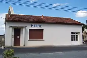 Rathaus (Mairie) von Saint-Sève | ||

Saint-Sève (okzitanisch Sent Sèver) ist eine französische Gemeinde mit 251 Einwohnern (Stand: 1. Januar 2019) im Département Gironde in der Region Nouvelle-Aquitaine. Sie gehört zum Arrondissement Langon und zum Kanton Le Réolais et Les Bastides. Die Einwohner werden Saint-Sévais genannt.
Geographie
Saint-Sève liegt etwa 65 Kilometer südöstlich von Bordeaux. Umgeben wird Saint-Sève von den Nachbargemeinden Loubens im Norden, Saint-Hilaire-de-la-Noaille im Osten und Südosten, La Réole im Süden sowie Bagas im Westen und Nordwesten.
Bevölkerungsentwicklung
| 1962 | 1968 | 1975 | 1982 | 1990 | 1999 | 2006 | 2017 |
|---|---|---|---|---|---|---|---|
| 163 | 175 | 130 | 150 | 177 | 193 | 205 | 254 |
| Quellen: Cassini und INSEE | |||||||
Sehenswürdigkeiten
- Kirche Saint-Sève aus dem 16. Jahrhundert
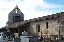
Kirche Saint-Sève
Literatur
- Le Patrimoine des Communes de la Gironde. Flohic Éditions, Band 2, Paris 2001, ISBN 2-84234-125-2, S. 1238.
Weblinks
Commons: Saint-Sève – Sammlung von Bildern, Videos und Audiodateien
This article is issued from Wikipedia. The text is licensed under Creative Commons - Attribution - Sharealike. The authors of the article are listed here. Additional terms may apply for the media files, click on images to show image meta data.