Saint-Maixant (Gironde)
Saint-Maixant ist eine französische Gemeinde mit 1.994 Einwohnern (Stand 1. Januar 2019) im Département Gironde in der Region Nouvelle-Aquitaine (vor 2016 Aquitaine). Sie gehört zum Arrondissement Langon und zum Kanton L’Entre-deux-Mers (bis 2015 Saint-Macaire). Die Einwohner werden Saint-Maixantais genannt.
| Saint-Maixant | ||
|---|---|---|
.svg.png.webp)
|
| |
| Staat | Frankreich | |
| Region | Nouvelle-Aquitaine | |
| Département (Nr.) | Gironde (33) | |
| Arrondissement | Langon | |
| Kanton | L’Entre-deux-Mers | |
| Gemeindeverband | Sud Gironde | |
| Koordinaten | 44° 35′ N, 0° 16′ W | |
| Höhe | 0–98 m | |
| Fläche | 7,53 km² | |
| Einwohner | 1.994 (1. Januar 2019) | |
| Bevölkerungsdichte | 265 Einw./km² | |
| Postleitzahl | 33490 | |
| INSEE-Code | 33438 | |
| Website | http://saintmaixant.fr/z/index.php | |
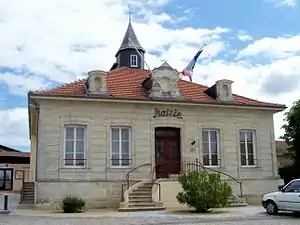 Rathaus Saint-Maixant | ||

Geographie
Saint-Maixant liegt im Südwesten Frankreichs. Die Garonne begrenzt die Gemeinde im Südwesten. Nördlich der Gemeinde liegt Verdelais, nordöstlich Saint-André-du-Bois, östlich Le Pian-sur-Garonne, südöstlich Saint-Macaire, südlich Langon sowie westlich und südwestlich Toulenne.
Bevölkerungsentwicklung
| Jahr | 1962 | 1968 | 1975 | 1982 | 1990 | 1999 | 2008 | 2013 |
| Einwohner | 830 | 925 | 1018 | 1203 | 1349 | 1277 | 1375 | 1760 |
| Quelle: Cassini und INSEE | ||||||||
Sehenswürdigkeiten
- Kirche Saint-Maixant aus dem 12. Jahrhundert, Monument historique seit 1925, mit Skulptur Madonna mit Kind (Monument historique)
- Domäne Malagar aus dem 18. Jahrhundert, Monument historique
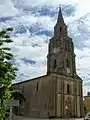 Kirche Saint-Maixant
 Domäne Malagar
Literatur
- Le Patrimoine des Communes de la Gironde. Flohic Éditions, Band 2, Paris 2001, ISBN 2-84234-125-2, S. 1335.
This article is issued from Wikipedia. The text is licensed under Creative Commons - Attribution - Sharealike. The authors of the article are listed here. Additional terms may apply for the media files, click on images to show image meta data.