Mourens
Mourens (okzitanisch Morens) ist eine französische Gemeinde mit 385 Einwohnern (Stand: 1. Januar 2019) im Département Gironde in der Region Nouvelle-Aquitaine. Sie gehört zum Arrondissement Langon und zum Kanton L’Entre-deux-Mers.
| Mourens Morens | ||
|---|---|---|
| ||
| Staat | Frankreich | |
| Region | Nouvelle-Aquitaine | |
| Département (Nr.) | Gironde (33) | |
| Arrondissement | Langon | |
| Kanton | L’Entre-deux-Mers | |
| Gemeindeverband | Rurales de l’Entre-Deux-Mers | |
| Koordinaten | 44° 39′ N, 0° 13′ W | |
| Höhe | 47–116 m | |
| Fläche | 10,72 km² | |
| Einwohner | 385 (1. Januar 2019) | |
| Bevölkerungsdichte | 36 Einw./km² | |
| Postleitzahl | 33410 | |
| INSEE-Code | 33299 | |
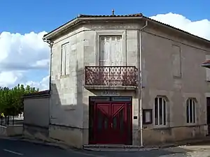 Rathaus (Mairie) von Mourens | ||

Geographie
Mourens liegt etwa 40 Kilometer südöstlich von Bordeaux. Umgeben wird Mourens von den Nachbargemeinden Saint-Pierre-de-Bat im Norden, Gornac im Nordosten, Saint-Martial im Osten und Südosten, Saint-Germain-de-Grave im Süden und Südwesten, Donzac im Westen sowie Porte-de-Benauge im Nordwesten.
Bevölkerungsentwicklung
| 1962 | 1968 | 1975 | 1982 | 1990 | 1999 | 2006 | 2017 |
|---|---|---|---|---|---|---|---|
| 452 | 434 | 385 | 382 | 341 | 358 | 388 | 385 |
| Quellen: cassini und INSEE | |||||||
Sehenswürdigkeiten
- Kirche Saint-Martin aus dem 12. Jahrhundert (Monument historique)
- Kirche Saint-Pierre in Montpezat
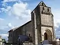 Kirche Saint-Martin
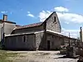 Kirche Saint-Pierre in Montpezat
Literatur
- Le Patrimoine des Communes de la Gironde. Flohic Éditions, Band 2, Paris 2001, ISBN 2-84234-125-2, S. 1482–1484.
Weblinks
Commons: Mourens – Sammlung von Bildern, Videos und Audiodateien
This article is issued from Wikipedia. The text is licensed under Creative Commons - Attribution - Sharealike. The authors of the article are listed here. Additional terms may apply for the media files, click on images to show image meta data.