Ongles
Ongles ist eine französische Gemeinde mit 365 Einwohnern (Stand 1. Januar 2019) im Département Alpes-de-Haute-Provence in der Region Provence-Alpes-Côte d’Azur. Sie gehört zum Kanton Forcalquier im Arrondissement Forcalquier. Die Bewohner nennen sich Onglois.
| Ongles | ||
|---|---|---|

|
| |
| Staat | Frankreich | |
| Region | Provence-Alpes-Côte d’Azur | |
| Département (Nr.) | Alpes-de-Haute-Provence (04) | |
| Arrondissement | Forcalquier | |
| Kanton | Forcalquier | |
| Gemeindeverband | Pays Forcalquier et Montagne de Lure | |
| Koordinaten | 44° 2′ N, 5° 44′ O | |
| Höhe | 517–1320 m | |
| Fläche | 31,65 km² | |
| Einwohner | 365 (1. Januar 2019) | |
| Bevölkerungsdichte | 12 Einw./km² | |
| Postleitzahl | 04230 | |
| INSEE-Code | 04141 | |
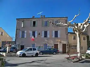 Mairie Ongles | ||

Geographie
Der Dorfkern befindet sich auf 613 m im Bereich der Seealpen. Ongles grenzt im Norden an Lardiers, im Osten an Saint-Étienne-les-Orgues, im Südosten an Forcalquier, im Süden an Limans, im Südwesten an Revest-des-Brousses und im Westen an Banon.
Bevölkerungsentwicklung
| Jahr | 1962 | 1968 | 1975 | 1982 | 1990 | 1999 | 2008 | 2012 |
|---|---|---|---|---|---|---|---|---|
| Einwohner | 237 | 240 | 187 | 197 | 239 | 278 | 331 | 347 |
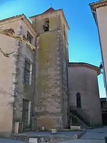
Turm der Kirche Notre-Dame
Weblinks
Commons: Ongles (Alpes-de-Haute-Provence) – Sammlung von Bildern, Videos und Audiodateien
This article is issued from Wikipedia. The text is licensed under Creative Commons - Attribution - Sharealike. The authors of the article are listed here. Additional terms may apply for the media files, click on images to show image meta data.