Montlaux
Montlaux ist eine französische Gemeinde mit 203 Einwohnern (Stand 1. Januar 2019) im Département Alpes-de-Haute-Provence in der Region Provence-Alpes-Côte d’Azur. Sie gehört zum Kanton Forcalquier im Arrondissement Forcalquier.
| Montlaux | ||
|---|---|---|

|
| |
| Staat | Frankreich | |
| Region | Provence-Alpes-Côte d’Azur | |
| Département (Nr.) | Alpes-de-Haute-Provence (04) | |
| Arrondissement | Forcalquier | |
| Kanton | Forcalquier | |
| Gemeindeverband | Pays Forcalquier et Montagne de Lure | |
| Koordinaten | 44° 3′ N, 5° 51′ O | |
| Höhe | 492–807 m | |
| Fläche | 19,75 km² | |
| Einwohner | 203 (1. Januar 2019) | |
| Bevölkerungsdichte | 10 Einw./km² | |
| Postleitzahl | 04230 | |
| INSEE-Code | 04130 | |
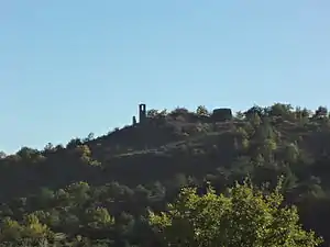 Burgruine in Vieux-Montlaux | ||

Geographie
921 Hektar der Gemeindegemarkung sind bewaldet. Montlaux grenzt im Norden an Cruis, im Osten an Mallefougasse-Augès, im Südosten an Peyruis (Berührungspunkt) und Sigonce, im Südwesten an Revest-Saint-Martin und im Westen an Saint-Étienne-les-Orgues.
Bevölkerungsentwicklung
| Jahr | 1962 | 1968 | 1975 | 1982 | 1990 | 1999 | 2008 | 2012 |
|---|---|---|---|---|---|---|---|---|
| Einwohner | 89 | 87 | 91 | 118 | 117 | 132 | 133 | 115 |
This article is issued from Wikipedia. The text is licensed under Creative Commons - Attribution - Sharealike. The authors of the article are listed here. Additional terms may apply for the media files, click on images to show image meta data.