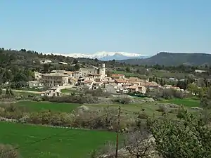
Sigonce
Sigonce ist eine französische Gemeinde mit 425 Einwohnern (Stand 1. Januar 2019) im Département Alpes-de-Haute-Provence in der Region Provence-Alpes-Côte d’Azur. Sie gehört zum Kanton Forcalquier im Arrondissement Forcalquier.
| Sigonce | ||
|---|---|---|

|
| |
| Staat | Frankreich | |
| Region | Provence-Alpes-Côte d’Azur | |
| Département (Nr.) | Alpes-de-Haute-Provence (04) | |
| Arrondissement | Forcalquier | |
| Kanton | Forcalquier | |
| Gemeindeverband | Pays Forcalquier et Montagne de Lure | |
| Koordinaten | 44° 0′ N, 5° 50′ O | |
| Höhe | 414–744 m | |
| Fläche | 20,42 km² | |
| Einwohner | 425 (1. Januar 2019) | |
| Bevölkerungsdichte | 21 Einw./km² | |
| Postleitzahl | 04300 | |
| INSEE-Code | 04206 | |
 Sigonce | ||

Geographie
Das Dorf befindet sich auf 470 m, neun Kilometer nordöstlich von Forcalquier. Die weiteren Nachbargemeinden sind
- Fontienne im Westen,
- Revest-Saint-Martin und Montlaux im Norden,
- Mallefougasse-Augès (Berührungspunkt) im Nordosten,
- Peyruis und Ganagobie im Osten,
- Lurs und Pierrerue im Süden.
Bevölkerungsentwicklung
| Jahr | 1962 | 1968 | 1975 | 1982 | 1990 | 1999 | 2005 | 2012 |
|---|---|---|---|---|---|---|---|---|
| Einwohner | 223 | 173 | 180 | 208 | 279 | 319 | 385 | 399 |
Sehenswürdigkeiten
- Schloss Bel Air, Monument historique
- Kirche Saint-Claude, Monument historique
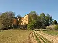 Schloss Bel Air
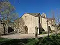 Kirche Saint-Claude
Weblinks
Commons: Sigonce – Sammlung von Bildern, Videos und Audiodateien
This article is issued from Wikipedia. The text is licensed under Creative Commons - Attribution - Sharealike. The authors of the article are listed here. Additional terms may apply for the media files, click on images to show image meta data.