Ganagobie
Ganagobie ist eine französische Gemeinde mit 92 Einwohnern (Stand 1. Januar 2019) im Département Alpes-de-Haute-Provence in der Region Provence-Alpes-Côte d’Azur. Sie gehört zum Arrondissement Digne-les-Bains und zum Kanton Château-Arnoux-Saint-Auban. Die Bewohner nennen sich die Ganagobiens.
| Ganagobie | ||
|---|---|---|

|
| |
| Staat | Frankreich | |
| Region | Provence-Alpes-Côte d’Azur | |
| Département (Nr.) | Alpes-de-Haute-Provence (04) | |
| Arrondissement | Digne-les-Bains | |
| Kanton | Château-Arnoux-Saint-Auban | |
| Gemeindeverband | Provence-Alpes-Agglomération | |
| Koordinaten | 44° 1′ N, 5° 55′ O | |
| Höhe | 367–719 m | |
| Fläche | 10,64 km² | |
| Einwohner | 92 (1. Januar 2019) | |
| Bevölkerungsdichte | 9 Einw./km² | |
| Postleitzahl | 04310 | |
| INSEE-Code | 04091 | |

Geographie
Die angrenzenden Gemeinden sind Peyruis im Norden, Les Mées im Osten, Lurs im Süden und Sigonce im Westen. Die Gemeindegemarkung wird im Osten vom Fluss Durance flankiert.
Bevölkerungsentwicklung
| Jahr | 1962 | 1968 | 1975 | 1982 | 1990 | 1999 | 2007 | 2012 |
|---|---|---|---|---|---|---|---|---|
| Einwohner | 10 | 121 | 50 | 64 | 75 | 91 | 106 | 84 |
Baudenkmäler
Siehe auch: Liste der Monuments historiques in Ganagobie
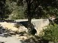 Pont du Buès, eine römische Brücke
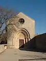 Prieuré de Ganagobie
This article is issued from Wikipedia. The text is licensed under Creative Commons - Attribution - Sharealike. The authors of the article are listed here. Additional terms may apply for the media files, click on images to show image meta data.