Saint-Marcel-Campes
Saint-Marcel-Campes (okzitanisch: Sent Marcèl e Campas) ist eine französische Gemeinde mit 213 Einwohnern (Stand: 1. Januar 2019) im Département Tarn in der Region Okzitanien. Sie gehört zum Arrondissement Albi und zum Kanton Carmaux-2 Vallée du Cérou.
| Saint-Marcel-Campes Sent Marcèl e Campas | ||
|---|---|---|
| ||
| Staat | Frankreich | |
| Region | Okzitanien | |
| Département (Nr.) | Tarn (81) | |
| Arrondissement | Albi | |
| Kanton | Carmaux-2 Vallée du Cérou | |
| Gemeindeverband | Cordais et Causse | |
| Koordinaten | 44° 5′ N, 1° 59′ O | |
| Höhe | 158–448 m | |
| Fläche | 22,57 km² | |
| Einwohner | 213 (1. Januar 2019) | |
| Bevölkerungsdichte | 9 Einw./km² | |
| Postleitzahl | 81170 | |
| INSEE-Code | 81262 | |

Geographie
Saint-Marcel-Campes liegt rund 23 Kilometer nordnordwestlich von Albi am Cérou. Umgeben wird Saint-Marcel-Campes von den Nachbargemeinden Lacapelle-Ségalar im Norden, Laparrouquial im Norden und Nordosten, Le Ségur im Nordosten, Salles im Osten, Livers-Cazelles im Süden, Cordes-sur-Ciel im Westen und Südwesten sowie Bournazel im Westen und Nordwesten.
Bevölkerungsentwicklung
| Jahr | 1962 | 1968 | 1975 | 1982 | 1990 | 1999 | 2006 | 2013 |
| Einwohner | 192 | 148 | 234 | 231 | 244 | 222 | 240 | 209 |
| Quelle: Cassini und INSEE | ||||||||
Sehenswürdigkeiten
- Kirche La Nativité-de-la-Vierge
- Kirche Saint-Michel
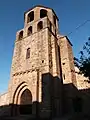 Kirche La Nativité-de-la-Vierge
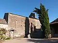 Kirche Saint-Michel
Weblinks
Commons: Saint-Marcel-Campes – Sammlung von Bildern, Videos und Audiodateien
This article is issued from Wikipedia. The text is licensed under Creative Commons - Attribution - Sharealike. The authors of the article are listed here. Additional terms may apply for the media files, click on images to show image meta data.