Saint-Cyr-du-Bailleul
Saint-Cyr-du-Bailleul ist eine französische Gemeinde mit 369 Einwohnern (Stand: 1. Januar 2019) im Département Manche in der Region Normandie. Die Gemeinde gehört zum Arrondissement Avranches und zum Kanton Le Mortainais. Die Einwohner werden Saint-Cyriens genannt.
| Saint-Cyr-du-Bailleul | ||
|---|---|---|
| ||
| Staat | Frankreich | |
| Region | Normandie | |
| Département (Nr.) | Manche (50) | |
| Arrondissement | Avranches | |
| Kanton | Le Mortainais | |
| Gemeindeverband | Mont-Saint-Michel-Normandie | |
| Koordinaten | 48° 34′ N, 0° 48′ W | |
| Höhe | 92–226 m | |
| Fläche | 23,43 km² | |
| Einwohner | 369 (1. Januar 2019) | |
| Bevölkerungsdichte | 16 Einw./km² | |
| Postleitzahl | 50720 | |
| INSEE-Code | 50462 | |
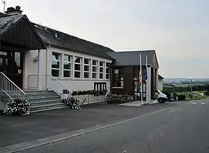 Rathaus (Mairie) von Saint-Cyr-du-Bailleul | ||

Geographie
Saint-Cyr-du-Bailleul liegt etwa 50 Kilometer ostsüdöstlich des Stadtzentrums von Avranches. Die Gemeinde gehört zum Regionalen Naturpark Normandie-Maine. Umgeben wird Saint-Cyr-du-Bailleul von den Nachbargemeinden Barenton im Norden, Saint-Georges-de-Rouelley im Nordosten, Saint-Roch-sur-Égrenne im Osten, Saint-Mars-d’Égrenne im Südosten, Mantilly im Süden und Le Teilleul im Südwesten und Westen.
Bevölkerungsentwicklung
| Jahr | 1962 | 1968 | 1975 | 1982 | 1990 | 1999 | 2006 | 2018 |
| Einwohner | 858 | 699 | 660 | 625 | 490 | 444 | 428 | 384 |
| Quellen: Cassini und INSEE | ||||||||
Sehenswürdigkeiten
- Menhir Pierre Saint-Martin
- Kirche Saint-Cyr-et-Sainte-Julitte
- Kapelle von Le Jarry
- Schloss Le Bailleul
- Schloss La Motte
.JPG.webp) Menhir Saint-Pierre
Menhir Saint-Pierre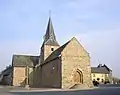 Kirche Saint-Cyr-et-Sainte-Julitte
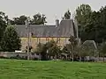 Schloss Le Bailleul
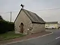 Kapelle von Le Jarry
This article is issued from Wikipedia. The text is licensed under Creative Commons - Attribution - Sharealike. The authors of the article are listed here. Additional terms may apply for the media files, click on images to show image meta data.