Saint-Aubin-des-Préaux
Saint-Aubin-des-Préaux ist eine französische Gemeinde mit 458 Einwohnern (Stand: 1. Januar 2019) im Département Manche in der Region Normandie. Sie gehört zum Arrondissement Avranches und zum Kanton Bréhal. Die Einwohner werden Saint-Aubinais genannt.
| Saint-Aubin-des-Préaux | ||
|---|---|---|
| ||
| Staat | Frankreich | |
| Region | Normandie | |
| Département (Nr.) | Manche (50) | |
| Arrondissement | Avranches | |
| Kanton | Bréhal | |
| Gemeindeverband | Granville, Terre et Mer | |
| Koordinaten | 48° 48′ N, 1° 30′ W | |
| Höhe | 11–94 m | |
| Fläche | 8,46 km² | |
| Einwohner | 458 (1. Januar 2019) | |
| Bevölkerungsdichte | 54 Einw./km² | |
| Postleitzahl | 50380 | |
| INSEE-Code | 50447 | |
| Website | https://saint-aubin-des-preaux.fr/ | |
 Rathaus (Mairie) von Saint-Aubin-des-Préaux | ||

Geografie
Saint-Aubin-des-Préaux liegt etwa sieben Kilometer südöstlich von Granville, einer kleinen Küstenstadt am Golf von Saint-Malo, wenige Kilometer nördlich des Mont-Saint-Michel. Die Gemeinde wird von den Nachbargemeinden Saint-Planchers im Norden, Saint-Jean-des-Champs im Osten, Saint-Pierre-Langers im Süden sowie Saint-Pair-sur-Mer im Westen umgeben.
Bevölkerungsentwicklung
| Jahr | 1962 | 1968 | 1975 | 1982 | 1990 | 1999 | 2006 | 2018 |
| Einwohner | 279 | 274 | 268 | 314 | 339 | 379 | 404 | 444 |
| Quellen: Cassini und INSEE | ||||||||
Sehenswürdigkeiten
- romanische Kirche Saint-Aubin aus dem 12. Jahrhundert, Monument historique
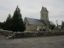
Kirche Saint-Aubin
This article is issued from Wikipedia. The text is licensed under Creative Commons - Attribution - Sharealike. The authors of the article are listed here. Additional terms may apply for the media files, click on images to show image meta data.