Dragey-Ronthon
Dragey-Ronthon ist eine französische Gemeinde mit 805 Einwohnern (Stand: 1. Januar 2019) im Département Manche in der Region Normandie. Sie gehört zum Arrondissement Avranches und zum Kanton Avranches.
| Dragey-Ronthon | ||
|---|---|---|
| ||
| Staat | Frankreich | |
| Region | Normandie | |
| Département (Nr.) | Manche (50) | |
| Arrondissement | Avranches | |
| Kanton | Avranches | |
| Gemeindeverband | Mont-Saint-Michel-Normandie | |
| Koordinaten | 48° 43′ N, 1° 30′ W | |
| Höhe | 6–115 m | |
| Fläche | 15,39 km² | |
| Einwohner | 805 (1. Januar 2019) | |
| Bevölkerungsdichte | 52 Einw./km² | |
| Postleitzahl | 50530 | |
| INSEE-Code | 50167 | |
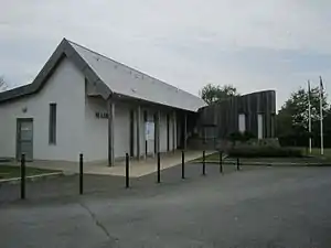 Mairie Dragey-Ronthon | ||

Lage
Die Gemeinde liegt am Ärmelkanal. Nachbargemeinden sind Saint-Jean-le-Thomas im Nordwesten, Champeaux, Jullouville und Sartilly-Baie-Bocage im Norden, Champcey im Osten, Bacilly im Südosten und Genêts im Süden.
Bevölkerungsentwicklung
| Jahr | 1962 | 1968 | 1975 | 1982 | 1990 | 1999 | 2008 | 2018 |
|---|---|---|---|---|---|---|---|---|
| Einwohner | 695 | 632 | 569 | 597 | 571 | 616 | 774 | 814 |
Sehenswürdigkeiten
- Kirche Saint-Médard in Dragey, Monument historique seit 1995
- Manoir de Potrel, Herrenhaus, Monument historique seit 1933
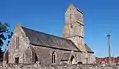 Kirche Saint-Médard
 Manoir de Potrel, Gemälde von Jan Griffier
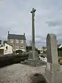 ehemalige Mairie in Ronthon
This article is issued from Wikipedia. The text is licensed under Creative Commons - Attribution - Sharealike. The authors of the article are listed here. Additional terms may apply for the media files, click on images to show image meta data.