La Chapelle-Urée
La Chapelle-Urée ist eine französische Gemeinde mit 165 Einwohnern (Stand: 1. Januar 2019) im Département Manche in der Region Normandie. Sie gehört zum Arrondissement Avranches und zum Kanton Isigny-le-Buat.
| La Chapelle-Urée | ||
|---|---|---|
| ||
| Staat | Frankreich | |
| Region | Normandie | |
| Département (Nr.) | Manche (50) | |
| Arrondissement | Avranches | |
| Kanton | Isigny-le-Buat | |
| Gemeindeverband | Communauté d’agglomération Mont-Saint-Michel-Normandie | |
| Koordinaten | 48° 40′ N, 1° 9′ W | |
| Höhe | 140–237 m | |
| Fläche | 4,63 km² | |
| Einwohner | 165 (1. Januar 2019) | |
| Bevölkerungsdichte | 36 Einw./km² | |
| Postleitzahl | 50370 | |
| INSEE-Code | 50124 | |
.JPG.webp) Mairie La Chapelle-Urée | ||

Sie grenzt im Nordwesten an Le Grand-Celland, im Nordosten und im Osten an Reffuveille und im Süden und im Westen an Isigny-le-Buat.
Bevölkerungsentwicklung
| Jahr | 1962 | 1968 | 1975 | 1982 | 1990 | 1999 | 2008 | 2018 |
|---|---|---|---|---|---|---|---|---|
| Einwohner | 243 | 218 | 208 | 181 | 169 | 122 | 128 | 162 |
Sehenswürdigkeiten
- Kirche Notre-Dame-de-l’Assomption
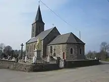
Kirche Notre-Dame
This article is issued from Wikipedia. The text is licensed under Creative Commons - Attribution - Sharealike. The authors of the article are listed here. Additional terms may apply for the media files, click on images to show image meta data.