Les Cresnays
Les Cresnays ist eine französische Gemeinde mit 225 Einwohnern (Stand: 1. Januar 2019) im Département Manche in der Region Normandie. Sie gehört zum Arrondissement Avranches und zum Kanton Isigny-le-Buat.
| Les Cresnays | ||
|---|---|---|
| ||
| Staat | Frankreich | |
| Region | Normandie | |
| Département (Nr.) | Manche (50) | |
| Arrondissement | Avranches | |
| Kanton | Isigny-le-Buat | |
| Gemeindeverband | Mont-Saint-Michel-Normandie | |
| Koordinaten | 48° 43′ N, 1° 7′ W | |
| Höhe | 32–131 m | |
| Fläche | 9,98 km² | |
| Einwohner | 225 (1. Januar 2019) | |
| Bevölkerungsdichte | 23 Einw./km² | |
| Postleitzahl | 50370 | |
| INSEE-Code | 50152 | |

Geografie
Les Cresnays grenzt im Nordwesten an Saint-Laurent-de-Cuves, im Norden an Cuves, im Osten an Le Mesnil-Adelée, im Süden an Reffuveille und im Westen an Brécey. Zur Gemeindegemarkung gehören neben der Hauptsiedlung auch die Weiler La Montellerie, La Bitardière, Les Moulins, La Lorerie, La Haute Garlière, Les Bourdonnais, La Saillanderie, La Pipouiserie, La Courtoiselière, La Basselinière, La Bouverie, L’Aumouillère, La Tuaudière, La Traversière, La Maitellerie, La Gougeonnière, La Torlière, La Droutière, La Guesnonnière, La Chardière, Bellefontaine, La Héraudière, La Tourie, La Maison Neuve, La Rainière, La Chèvrerie, La Fouacerie, La Fainière, La Cochardière, Les Verdières, La Gauterie, La Poupardière, Le Manoir, L’Éclairée, La Daitinière, La Rue Marot, Le Clos Née und Les Questures.
Bevölkerungsentwicklung
| Jahr | 1962 | 1968 | 1975 | 1982 | 1990 | 1999 | 2008 | 2018 |
|---|---|---|---|---|---|---|---|---|
| Einwohner | 472 | 425 | 374 | 308 | 287 | 271 | 253 | 227 |
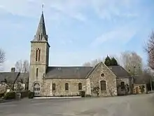
Sehenswürdigkeiten
- Kirche Saint-Pierre