Communauté d’agglomération Mont-Saint-Michel-Normandie
Die Communauté d’agglomération Mont-Saint-Michel-Normandie ist ein französischer Gemeindeverband mit der Rechtsform einer Communauté d’agglomération im Département Manche in der Region Normandie. Der Gemeindeverband wurde am 3. Oktober 2016 gegründet und umfasst 95 Gemeinden (Stand: 1. Januar 2019). Der Verwaltungssitz befindet sich in der Stadt Avranches.[2]
| Communauté d’agglomération Mont-Saint-Michel-Normandie | |
| Region(en) | Normandie |
| Département(s) | Manche |
| Gründungsdatum | 3. Oktober 2016 |
| Rechtsform | Communauté d’agglomération |
| Verwaltungssitz | Avranches |
| Gemeinden | 95 |
| Präsident | David Nicolas |
| SIREN-Nummer | 200 069 425 |
| Fläche | 1.560,90 km² |
| Einwohner | 87.613 (2019)[1] |
| Bevölkerungsdichte | 56 Einw./km² |
| Website | www.msm-normandie.fr |
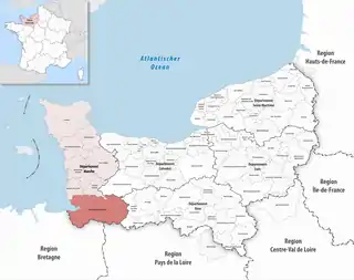 Lage des Gemeindeverbandes in der Region Normandie | |
Historische Entwicklung
Der Gemeindeverband entstand mit Wirkung vom 1. Januar 2017 durch die Fusion der Vorgängerorganisationen
- Communauté de communes de Saint-Hilaire-du-Harcouët,
- Communauté de communes de Saint-James,
- Communauté de communes d’Avranches Mont-Saint-Michel,
- Communauté de communes du Val de Sée und
- Communauté de communes du Mortainais.
Mit Wirkung vom 1. Januar 2019 gingen die ehemaligen Gemeinden Avranches und Saint-Martin-des-Champs in die Commune nouvelle Avranches auf und die ehemaligen Gemeinden Tirepied und La Gohannière gingen in die Commune nouvelle Tirepied-sur-Sée auf. Dadurch verringerte sich die Anzahl der Mitgliedsgemeinden auf 95.
Mitgliedsgemeinden
| Gemeinde | Einwohner 1. Januar 2019 |
Fläche km² |
Dichte Einw./km² |
Code INSEE |
Postleitzahl |
|---|---|---|---|---|---|
| Aucey-la-Plaine | 419 | 9,55 | 44 | 50019 | 50170 |
| Avranches | 10.264 | 10,92 | 940 | 50025 | 50300 |
| Bacilly | 956 | 16,45 | 58 | 50027 | 50530 |
| Barenton | 1.175 | 35,51 | 33 | 50029 | 50720 |
| Beauficel | 123 | 9,13 | 13 | 50040 | 50150 |
| Beauvoir | 433 | 14,40 | 30 | 50042 | 50170 |
| Brécey | 2.139 | 21,34 | 100 | 50074 | 50370 |
| Brouains | 135 | 3,83 | 35 | 50088 | 50150 |
| Buais-Les-Monts | 611 | 24,85 | 25 | 50090 | 50640 |
| Céaux | 414 | 8,52 | 49 | 50108 | 50220 |
| Chaulieu | 307 | 10,57 | 29 | 50514 | 50150 |
| Chavoy | 133 | 3,71 | 36 | 50126 | 50870 |
| Courtils | 235 | 5,45 | 43 | 50146 | 50220 |
| Crollon | 298 | 4,76 | 63 | 50155 | 50220 |
| Cuves | 280 | 9,70 | 29 | 50158 | 50670 |
| Dragey-Ronthon | 805 | 15,39 | 52 | 50167 | 50530 |
| Ducey-Les Chéris | 2.799 | 17,20 | 163 | 50168 | 50220 |
| Gathemo | 254 | 10,55 | 24 | 50195 | 50150 |
| Genêts | 447 | 7,07 | 63 | 50199 | 50530 |
| Ger | 807 | 39,82 | 20 | 50200 | 50850 |
| Grandparigny | 2.643 | 35,12 | 75 | 50391 | 50600 |
| Hamelin | 87 | 2,51 | 35 | 50229 | 50730 |
| Huisnes-sur-Mer | 170 | 6,85 | 25 | 50253 | 50170 |
| Isigny-le-Buat | 3.221 | 73,70 | 44 | 50256 | 50540 |
| Juilley | 641 | 11,41 | 56 | 50259 | 50220 |
| Juvigny les Vallées | 1.689 | 57,92 | 29 | 50260 | 50520 |
| La Chaise-Baudouin | 465 | 12,18 | 38 | 50112 | 50370 |
| La Chapelle-Urée | 165 | 4,63 | 36 | 50124 | 50370 |
| La Godefroy | 279 | 3,68 | 76 | 50205 | 50300 |
| Lapenty | 364 | 14,91 | 24 | 50263 | 50600 |
| Le Fresne-Poret | 218 | 10,17 | 21 | 50193 | 50850 |
| Le Grand-Celland | 601 | 12,78 | 47 | 50217 | 50370 |
| Le Grippon | 383 | 9,98 | 38 | 50115 | 50320 |
| Le Luot | 298 | 8,58 | 35 | 50282 | 50870 |
| Le Mesnil-Adelée | 164 | 6,88 | 24 | 50300 | 50520 |
| Le Mesnil-Gilbert | 134 | 7,93 | 17 | 50312 | 50670 |
| Le Mesnil-Ozenne | 272 | 4,69 | 58 | 50317 | 50220 |
| Le Mesnillard | 248 | 9,92 | 25 | 50315 | 50600 |
| Le Mont-Saint-Michel | 29 | 3,99 | 7 | 50353 | 50170 |
| Le Neufbourg | 407 | 2,22 | 183 | 50371 | 50140 |
| Le Parc | 921 | 22,73 | 41 | 50535 | 50870 |
| Le Petit-Celland | 178 | 6,72 | 26 | 50399 | 50370 |
| Le Teilleul | 1.674 | 67,82 | 25 | 50591 | 50640 |
| Le Val-Saint-Père | 1.971 | 11,32 | 174 | 50616 | 50300 |
| Les Cresnays | 225 | 9,98 | 23 | 50152 | 50370 |
| Les Loges-Marchis | 1.012 | 20,33 | 50 | 50274 | 50600 |
| Les Loges-sur-Brécey | 125 | 5,42 | 23 | 50275 | 50370 |
| Lingeard | 86 | 3,63 | 24 | 50271 | 50670 |
| Lolif | 583 | 12,65 | 46 | 50276 | 50530 |
| Marcey-les-Grèves | 1.294 | 6,69 | 193 | 50288 | 50300 |
| Marcilly | 324 | 8,96 | 36 | 50290 | 50220 |
| Montjoie-Saint-Martin | 234 | 7,48 | 31 | 50347 | 50240 |
| Mortain-Bocage | 2.929 | 62,98 | 47 | 50359 | 50140 |
| Moulines | 285 | 7,55 | 38 | 50362 | 50600 |
| Notre-Dame-de-Livoye | 159 | 3,62 | 44 | 50379 | 50370 |
| Perriers-en-Beauficel | 210 | 9,27 | 23 | 50397 | 50150 |
| Poilley | 929 | 12,98 | 72 | 50407 | 50220 |
| Pontaubault | 569 | 1,85 | 308 | 50408 | 50220 |
| Pontorson | 4.318 | 62,19 | 69 | 50410 | 50170 |
| Ponts | 678 | 6,75 | 100 | 50411 | 50300 |
| Précey | 574 | 7,88 | 73 | 50413 | 50220 |
| Reffuveille | 513 | 23,72 | 22 | 50428 | 50520 |
| Romagny Fontenay | 1.278 | 36,34 | 35 | 50436 | 50140 |
| Sacey | 516 | 15,34 | 34 | 50443 | 50170 |
| Saint-Aubin-de-Terregatte | 661 | 21,38 | 31 | 50448 | 50240 |
| Saint-Barthélemy | 333 | 6,90 | 48 | 50450 | 50140 |
| Saint-Brice | 127 | 2,53 | 50 | 50451 | 50300 |
| Saint-Brice-de-Landelles | 664 | 15,41 | 43 | 50452 | 50730 |
| Saint-Clément-Rancoudray | 548 | 32,74 | 17 | 50456 | 50140 |
| Saint-Cyr-du-Bailleul | 369 | 23,43 | 16 | 50462 | 50720 |
| Saint-Georges-de-Livoye | 204 | 5,61 | 36 | 50472 | 50370 |
| Saint-Georges-de-Rouelley | 545 | 20,78 | 26 | 50474 | 50720 |
| Saint-Hilaire-du-Harcouët | 5.850 | 47,29 | 124 | 50484 | 50600, 50730 |
| Saint-James | 4.907 | 87,47 | 56 | 50487 | 50240 |
| Saint-Jean-de-la-Haize | 531 | 9,07 | 59 | 50489 | 50300 |
| Saint-Jean-du-Corail-des-Bois | 75 | 3,62 | 21 | 50495 | 50370 |
| Saint-Jean-le-Thomas | 384 | 2,52 | 152 | 50496 | 50530 |
| Saint-Laurent-de-Cuves | 481 | 14,81 | 32 | 50499 | 50670 |
| Saint-Laurent-de-Terregatte | 654 | 16,69 | 39 | 50500 | 50240 |
| Saint-Loup | 679 | 6,48 | 105 | 50505 | 50300 |
| Saint-Michel-de-Montjoie | 328 | 14,52 | 23 | 50525 | 50670 |
| Saint-Nicolas-des-Bois | 81 | 3,66 | 22 | 50529 | 50370 |
| Saint-Ovin | 767 | 12,90 | 59 | 50531 | 50220 |
| Saint-Quentin-sur-le-Homme | 1.345 | 17,00 | 79 | 50543 | 50220 |
| Saint-Senier-de-Beuvron | 346 | 11,15 | 31 | 50553 | 50240 |
| Saint-Senier-sous-Avranches | 1.420 | 8,70 | 163 | 50554 | 50300 |
| Sartilly-Baie-Bocage | 2.815 | 31,06 | 91 | 50565 | 50530 |
| Savigny-le-Vieux | 426 | 17,31 | 25 | 50570 | 50640 |
| Servon | 271 | 9,22 | 29 | 50574 | 50170 |
| Sourdeval | 3.156 | 52,82 | 60 | 50582 | 50150 |
| Subligny | 407 | 7,91 | 51 | 50584 | 50870 |
| Tanis | 289 | 7,47 | 39 | 50589 | 50170 |
| Tirepied-sur-Sée | 953 | 22,90 | 42 | 50597 | 50300, 50870 |
| Vains | 745 | 8,70 | 86 | 50612 | 50300 |
| Vernix | 155 | 5,94 | 26 | 50628 | 50370 |
| Communauté d’agglomération Mont-Saint-Michel-Normandie |
87.613 | 1.560,90 | 56 | – | – |
Quellen
- www.collectivites-locales.gouv.fr
- CA Mont-Saint-Michel-Normandie (SIREN: 200 069 425) in der Base nationale sur l’intercommunalité (BANATIC) des französischen Innenministeriums (französisch), abgerufen am 6. September 2017.