Saint-Bauzille-de-Montmel
| Saint-Bauzille-de-Montmel Sant Bausèli de Montmèu | ||
|---|---|---|
.svg.png.webp)
|
| |
| Staat | Frankreich | |
| Region | Okzitanien | |
| Département (Nr.) | Hérault (34) | |
| Arrondissement | Lodève | |
| Kanton | Saint-Gély-du-Fesc | |
| Gemeindeverband | Grand Pic Saint-Loup | |
| Koordinaten | 43° 46′ N, 3° 57′ O | |
| Höhe | 62–320 m | |
| Fläche | 21,36 km² | |
| Einwohner | 1.074 (1. Januar 2019) | |
| Bevölkerungsdichte | 50 Einw./km² | |
| Postleitzahl | 34160 | |
| INSEE-Code | 34242 | |
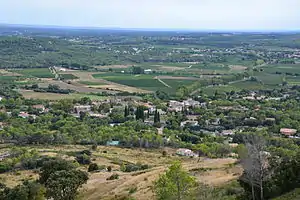 Blick auf Saint-Bauzille-de-Montmel | ||

Saint-Bauzille-de-Montmel (okzitanisch: Sant Bausèli de Montmèu) ist eine französische Gemeinde mit 1074 Einwohnern (Stand 1. Januar 2019) im Département Hérault in der Region Okzitanien. Sie gehört zum Arrondissement Lodève sowie zum Kanton Saint-Gély-du-Fesc (bis 2015: Kanton Les Matelles). Die Einwohner werden Saint-Bauzillois genannt.
Geographie
Saint-Bauzille-de-Montmel liegt etwa 18 Kilometer nordnordöstlich von Montpellier. Umgeben wird Saint-Bauzille-de-Montmel von den Nachbargemeinden Vacquières im Norden, Carnas im Nordosten, Galargues im Osten und Nordosten, Buzignargues im Osten, Montaud im Süden, Saint-Mathieu-de-Tréviers im Westen und Südwesten, Sainte-Croix-de-Quintillargues im Westen sowie Fontanès im Westen und Nordwesten.
Bevölkerungsentwicklung
| Bevölkerungsentwicklung | ||||||||
|---|---|---|---|---|---|---|---|---|
| Jahr | 1962 | 1968 | 1975 | 1982 | 1990 | 1999 | 2006 | 2017 |
| Einwohner | 330 | 354 | 370 | 456 | 479 | 734 | 883 | 1022 |
| Quellen: Cassini und INSEE | ||||||||
Sehenswürdigkeiten
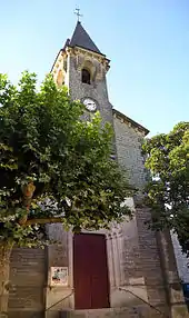
Kirche Saint-Bauzille
- Kirche Saint-Bauzille aus dem Jahre 1870
- protestantische Kirche
- alte Kirche Saint-Germain in der Ortschaft Fournes
This article is issued from Wikipedia. The text is licensed under Creative Commons - Attribution - Sharealike. The authors of the article are listed here. Additional terms may apply for the media files, click on images to show image meta data.