Sahorre
Sahorre ist eine französische Gemeinde mit 391 Einwohnern (Stand 1. Januar 2019) im Département Pyrénées-Orientales in der Region Okzitanien. Sie gehört zum Arrondissement Prades und zum Kanton Le Canigou.
| Sahorre | ||
|---|---|---|
|
| |
| Staat | Frankreich | |
| Region | Okzitanien | |
| Département (Nr.) | Pyrénées-Orientales (66) | |
| Arrondissement | Prades | |
| Kanton | Le Canigou | |
| Gemeindeverband | Conflent-Canigó | |
| Koordinaten | 42° 32′ N, 2° 22′ O | |
| Höhe | 599–2082 m | |
| Fläche | 15,14 km² | |
| Einwohner | 391 (1. Januar 2019) | |
| Bevölkerungsdichte | 26 Einw./km² | |
| Postleitzahl | 66360 | |
| INSEE-Code | 66166 | |
| Website | http://mairie.sahorre.free.fr/ | |
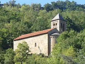 Kirche Saint-Ètienne | ||

Nachbargemeinden
Nachbargemeinden von Sahorre sind Fuilla im Norden, Vernet-les-Bains im Nordosten, Casteil im Osten, Py im Süden, Nyer im Südwesten, sowie Escaro im Westen.
Bevölkerungsentwicklung
| Jahr | 1962 | 1968 | 1975 | 1982 | 1990 | 1999 | 2017 |
| Einwohner | 626 | 445 | 370 | 359 | 333 | 347 | 382 |
Sehenswürdigkeiten
- Romanische Kirche Saint-Étienne (12. Jahrhundert)
- Romanische Kirche Sainte-Croix in Thorrent
- Tour de Goa (Monument historique)
This article is issued from Wikipedia. The text is licensed under Creative Commons - Attribution - Sharealike. The authors of the article are listed here. Additional terms may apply for the media files, click on images to show image meta data.