Fontpédrouse
Fontpédrouse ist eine französische Gemeinde mit 117 Einwohnern (Stand 1. Januar 2019) im Département Pyrénées-Orientales in der Region Okzitanien. Sie gehört zum Arrondissement Prades und zum Kanton Les Pyrénées catalanes.
| Fontpédrouse | ||
|---|---|---|
| ||
| Staat | Frankreich | |
| Region | Okzitanien | |
| Département (Nr.) | Pyrénées-Orientales (66) | |
| Arrondissement | Prades | |
| Kanton | Les Pyrénées catalanes | |
| Gemeindeverband | Conflent-Canigó | |
| Koordinaten | 42° 31′ N, 2° 11′ O | |
| Höhe | 880–2865 m | |
| Fläche | 64,33 km² | |
| Einwohner | 117 (1. Januar 2019) | |
| Bevölkerungsdichte | 2 Einw./km² | |
| Postleitzahl | 66360 | |
| INSEE-Code | 66080 | |
| Website | http://www.fontpedrouse.fr/ | |
 Fontpédrouse | ||

Nachbargemeinden
Nachbargemeinden von Fontpédrouse sind Canaveilles im Norden, Thuès-Entre-Valls im Nordosten, Nyer im Osten, Mantet im Südosten, Queralbs und Setcases (Spanien) im Süden, Eyne im Südwesten, Planès im Westen und Sauto im Nordwesten.
Bevölkerungsentwicklung
| Jahr | 1962 | 1968 | 1975 | 1982 | 1990 | 1999 | 2013 |
| Einwohner | 243 | 188 | 147 | 108 | 138 | 123 | 131 |
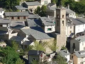
Sehenswürdigkeiten
- romanische Kirche La Trinité et Sainte-Marie in Prats-Balaguer (11. Jahrhundert)
- Pfarrkirche Saint-Marie
- Pont Séjourné
- Burgruine Prats-Balaguer
This article is issued from Wikipedia. The text is licensed under Creative Commons - Attribution - Sharealike. The authors of the article are listed here. Additional terms may apply for the media files, click on images to show image meta data.