Rilhac-Lastours
Rilhac-Lastours, auf okzitanisch „Rilhac las Tors“, ist eine Gemeinde in Frankreich. Sie gehört zur Region Nouvelle-Aquitaine, zum Département Haute-Vienne und zum Arrondissement Limoges. Die Gemeinde liegt im durch ein Dekret vom 24. August 2011 gebildeten Regionalen Naturpark Périgord-Limousin. Sie wurde 2015 zum Kanton Saint-Yrieix-la-Perche geschlagen. Die Nachbargemeinden sind Les Cars im Nordwesten, Flavignac im Norden, Nexon im Nordosten, Saint-Hilaire-les-Places im Osten und Bussière-Galant im Südwesten.
| Rilhac-Lastours | ||
|---|---|---|
.svg.png.webp)
|
| |
| Staat | Frankreich | |
| Region | Nouvelle-Aquitaine | |
| Département (Nr.) | Haute-Vienne (87) | |
| Arrondissement | Limoges | |
| Kanton | Saint-Yrieix-la-Perche | |
| Gemeindeverband | Pays de Nexon-Monts de Châlus | |
| Koordinaten | 45° 39′ N, 1° 7′ O | |
| Höhe | 315–557 m | |
| Fläche | 16,33 km² | |
| Einwohner | 373 (1. Januar 2019) | |
| Bevölkerungsdichte | 23 Einw./km² | |
| Postleitzahl | 87800 | |
| INSEE-Code | 87124 | |
 Rilhac-Lastours | ||
Geschichte
Die Ortschaft hieß während der Französischen Revolution „Rilhac-Chaumière“.
Bevölkerungsentwicklung
| Jahr | 1962 | 1968 | 1975 | 1982 | 1990 | 1999 | 2007 | 2013 |
|---|---|---|---|---|---|---|---|---|
| Einwohner | 497 | 416 | 356 | 321 | 302 | 313 | 338 | 375 |
Sehenswürdigkeiten
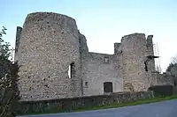
- Burgruine von Lastours, Monument historique
- Kirche Saint-Pierre-ès-Liens, Monument historique
 Burgruine von Lastours
 Kirche Saint-Pierre-ès-Liens
This article is issued from Wikipedia. The text is licensed under Creative Commons - Attribution - Sharealike. The authors of the article are listed here. Additional terms may apply for the media files, click on images to show image meta data.
