Pont-sur-Seine
| Pont-sur-Seine | ||
|---|---|---|

|
| |
| Staat | Frankreich | |
| Region | Grand Est | |
| Département (Nr.) | Aube (10) | |
| Arrondissement | Nogent-sur-Seine | |
| Kanton | Nogent-sur-Seine | |
| Gemeindeverband | Nogentais | |
| Koordinaten | 48° 31′ N, 3° 36′ O | |
| Höhe | 63–208 m | |
| Fläche | 16,06 km² | |
| Einwohner | 1.159 (1. Januar 2019) | |
| Bevölkerungsdichte | 72 Einw./km² | |
| Postleitzahl | 10400 | |
| INSEE-Code | 10298 | |

Pont-sur-Seine ist eine französische Gemeinde mit 1159 Einwohnern (Stand 1. Januar 2019) im Département Aube in der Region Grand Est; sie gehört zum Arrondissement Nogent-sur-Seine und zum Kanton Nogent-sur-Seine. Pont-sur-Seine liegt an der Seine zwischen Romilly-sur-Seine und Nogent-sur-Seine.
Geschichte
Das 1814 von deutschen Truppen niedergebrannte Schloss hatte Napoleon seiner Mutter geschenkt, Madame Mère.
Im Jahr 1961 verübte Henri Manoury hier einen Bombenanschlag auf Charles de Gaulle.
Pont-sur-Seine besaß, von 1857 an, einen Bahnhof an der Bahnstrecke Paris–Mulhouse.
Bevölkerungsentwicklung
- 1962: 722
- 1968: 734
- 1975: 925
- 1982: 994
- 1990: 887
- 1999: 935
- 2007: 984
- 2016: 1161
Sehenswürdigkeiten

Kirche Saint-Martin
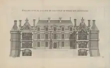
Das 1814 zerstörte Schloss
- Kirche Saint-Martin, erbaut ab dem 12. Jahrhundert (Monument historique)
Siehe auch
This article is issued from Wikipedia. The text is licensed under Creative Commons - Attribution - Sharealike. The authors of the article are listed here. Additional terms may apply for the media files, click on images to show image meta data.