Crancey
Crancey ist eine französische Gemeinde mit 706 Einwohnern (Stand 1. Januar 2019) im Département Aube in der Region Grand Est (vor 2016 Champagne-Ardenne); sie gehört zum Arrondissement Nogent-sur-Seine und zum Kanton Romilly-sur-Seine (bis 2015 Romilly-sur-Seine-1). Die Einwohner werden Cranceyons genannt.
| Crancey | ||
|---|---|---|
.svg.png.webp)
|
| |
| Staat | Frankreich | |
| Region | Grand Est | |
| Département (Nr.) | Aube (10) | |
| Arrondissement | Nogent-sur-Seine | |
| Kanton | Romilly-sur-Seine | |
| Gemeindeverband | Portes de Romilly-sur-Seine | |
| Koordinaten | 48° 31′ N, 3° 38′ O | |
| Höhe | 66–130 m | |
| Fläche | 8,86 km² | |
| Einwohner | 706 (1. Januar 2019) | |
| Bevölkerungsdichte | 80 Einw./km² | |
| Postleitzahl | 10100 | |
| INSEE-Code | 10114 | |

Geographie
Crancey liegt etwa 39 Kilometer nordwestlich von Troyes an der Seine, die die Gemeinde im Norden begrenzt. Umgeben wird Crancey von den Nachbargemeinden Périgny-la-Rose im Norden, Esclavolles-Lurey im Norden und Nordosten, Conflans-sur-Seine im Nordosten, Saint-Hilaire-sous-Romilly im Süden und Osten sowie Pont-sur-Seine im Westen.
Bevölkerungsentwicklung
| Jahr | 1962 | 1968 | 1975 | 1982 | 1990 | 1999 | 2006 | 2011 | 2016 |
| Einwohner | 528 | 563 | 849 | 928 | 833 | 840 | 817 | 798 | 730 |
| Quelle: Cassini und INSEE | |||||||||
Sehenswürdigkeiten
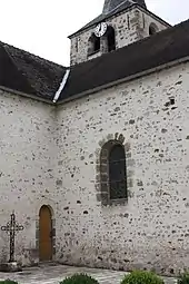
Kirche Saint-Loup
- Kirche Saint-Loup aus dem 12. Jahrhundert
This article is issued from Wikipedia. The text is licensed under Creative Commons - Attribution - Sharealike. The authors of the article are listed here. Additional terms may apply for the media files, click on images to show image meta data.