Bercenay-le-Hayer
Bercenay-le-Hayer ist eine französische Gemeinde mit 194 Einwohnern (Stand: 1. Januar 2019) im Département Aube in der Region Grand Est. Sie gehört zum Kanton Saint-Lyé und zum Arrondissement Nogent-sur-Seine.
| Bercenay-le-Hayer | ||
|---|---|---|
| ||
| Staat | Frankreich | |
| Region | Grand Est | |
| Département (Nr.) | Aube (10) | |
| Arrondissement | Nogent-sur-Seine | |
| Kanton | Saint-Lyé | |
| Gemeindeverband | Communauté de communes de l’Orvin et de l’Ardusson | |
| Koordinaten | 48° 21′ N, 3° 36′ O | |
| Höhe | 99–238 m | |
| Fläche | 14,86 km² | |
| Einwohner | 194 (1. Januar 2019) | |
| Bevölkerungsdichte | 13 Einw./km² | |
| Postleitzahl | 10290 | |
| INSEE-Code | 10038 | |

Sie ist umgeben von folgenden Nachbargemeinden:
| Trancault | Bourdenay | |
| Saint-Maurice-aux-Riches-Hommes | .svg.png.webp) |
Marcilly-le-Hayer |
| Courgenay | Pouy-sur-Vannes |
Bevölkerungsentwicklung
| Jahr | 1962 | 1968 | 1975 | 1982 | 1990 | 1999 | 2008 | 2016 |
|---|---|---|---|---|---|---|---|---|
| Einwohner | 167 | 146 | 137 | 147 | 151 | 135 | 137 | 187 |
| Quelle: Cassini und INSEE | ||||||||
Sehenswürdigkeiten
- Dolmen Pierre Couverte, Monument historique seit 1959
- Pfarrkirche Nativité-de-la-Vierge
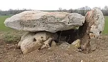
Pierre Couverte
This article is issued from Wikipedia. The text is licensed under Creative Commons - Attribution - Sharealike. The authors of the article are listed here. Additional terms may apply for the media files, click on images to show image meta data.