Montboucher-sur-Jabron
Montboucher-sur-Jabron ist eine französische Gemeinde mit 2.400 Einwohnern (Stand: 1. Januar 2019) im Département Drôme in der Region Auvergne-Rhône-Alpes. Montboucher-sur-Jabron gehört zum Arrondissement Nyons und zum Kanton Montélimar-2.
| Montboucher-sur-Jabron | ||
|---|---|---|
| ||
| Staat | Frankreich | |
| Region | Auvergne-Rhône-Alpes | |
| Département (Nr.) | Drôme (26) | |
| Arrondissement | Nyons | |
| Kanton | Montélimar-2 | |
| Gemeindeverband | Montélimar-Agglomération | |
| Koordinaten | 44° 33′ N, 4° 49′ O | |
| Höhe | 96–170 m | |
| Fläche | 9,97 km² | |
| Einwohner | 2.400 (1. Januar 2019) | |
| Bevölkerungsdichte | 241 Einw./km² | |
| Postleitzahl | 26740 | |
| INSEE-Code | 26191 | |
| Website | http://www.montboucher-sur-jabron.fr/ | |
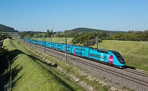 TGV Paris-Marseille bei Montboucher-sur-Jabron | ||

Geographie
Montboucher-sur-Jabron liegt am Rande der Provence am Jabron, der auch die südliche bzw. südöstliche Gemeindegrenze bildet. Umgeben wird Montboucher-sur-Jabron von den Nachbargemeinden Sauzet im Norden, La Bâtie-Rolland im Osten, Puygiron im Osten und Südosten, Espeluche im Süden sowie Montélimar im Westen.
Durch die Gemeinde führt die Autoroute A7.
Bevölkerungsentwicklung
| Jahr | 1962 | 1968 | 1975 | 1982 | 1990 | 1999 | 2006 | 2016 |
|---|---|---|---|---|---|---|---|---|
| Einwohner | 639 | 667 | 693 | 1042 | 1278 | 1424 | 1823 | 2273 |
| Quellen: Cassini und INSEE | ||||||||
Sehenswürdigkeiten
- früheres Kastell
- Schloss
- Wehrhaus
This article is issued from Wikipedia. The text is licensed under Creative Commons - Attribution - Sharealike. The authors of the article are listed here. Additional terms may apply for the media files, click on images to show image meta data.