Crupies
Crupies ist eine französische Gemeinde mit 100 Einwohnern (Stand 1. Januar 2019) im Département Drôme in der Region Auvergne-Rhône-Alpes. Sue gehört zum Arrondissement Die.
| Crupies | ||
|---|---|---|
| ||
| Staat | Frankreich | |
| Region | Auvergne-Rhône-Alpes | |
| Département (Nr.) | Drôme (26) | |
| Arrondissement | Nyons | |
| Kanton | Dieulefit | |
| Gemeindeverband | Dieulefit-Bourdeaux | |
| Koordinaten | 44° 33′ N, 5° 10′ O | |
| Höhe | 429–1088 m | |
| Fläche | 13,33 km² | |
| Einwohner | 100 (1. Januar 2019) | |
| Bevölkerungsdichte | 8 Einw./km² | |
| Postleitzahl | 26460 | |
| INSEE-Code | 26111 | |

Geografie
Das 13,16 km² große Gemeindegebiet wird vom Fluss Roubion durchquert. Das Siedlungsgebiet ist sehr klein, ein großer Anteil der Gemeindefläche von Crupies ist landwirtschaftlich genutztes Land.
Bevölkerungsentwicklung
| Jahr | 1962 | 1968 | 1975 | 1982 | 1990 | 1999 | 2007 | 2016 |
| Einwohner | 88 | 80 | 85 | 86 | 79 | 89 | 93 | 98 |
| Quellen: Cassini und INSEE | ||||||||
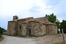
Kapelle Saint-Jean
Sehenswürdigkeiten
- Kapelle Saint-Jean-Baptiste aus dem 12. Jahrhundert
- Schlossruine Château de La Vialle
This article is issued from Wikipedia. The text is licensed under Creative Commons - Attribution - Sharealike. The authors of the article are listed here. Additional terms may apply for the media files, click on images to show image meta data.