Marcilly-sur-Maulne
| Marcilly-sur-Maulne | ||
|---|---|---|
.svg.png.webp)
|
| |
| Staat | Frankreich | |
| Region | Centre-Val de Loire | |
| Département (Nr.) | Indre-et-Loire (37) | |
| Arrondissement | Chinon | |
| Kanton | Langeais | |
| Gemeindeverband | Touraine Ouest Val de Loire | |
| Koordinaten | 47° 33′ N, 0° 15′ O | |
| Höhe | 47–121 m | |
| Fläche | 14,56 km² | |
| Einwohner | 219 (1. Januar 2019) | |
| Bevölkerungsdichte | 15 Einw./km² | |
| Postleitzahl | 37330 | |
| INSEE-Code | 37146 | |

Marcilly-sur-Maulne ist eine 219 Einwohner (Stand: 1. Januar 2019) zählende französische Gemeinde in der Region Centre-Val de Loire im Département Indre-et-Loire. Die Gemeinde gehört zum Arrondissement Chinon (bis einschließlich 2016: Arrondissement Tours) und zum Kanton Langeais (bis 2015: Kanton Château-la-Vallière). Die Einwohner werden Marcillais genannt.
Lage
Marcilly-sur-Maulne liegt etwa 41 Kilometer nordwestlich vom Stadtzentrum von Tours. Marcilly-sur-Maulne wird umgeben von den Nachbargemeinden Noyant-Villages im Norden, Süden und Westen, Villiers-au-Bouin im Nordosten, Braye-sur-Maulne im Osten sowie Lublé im Süden und Südosten.
Bevölkerungsentwicklung
| Jahr | 1962 | 1968 | 1975 | 1982 | 1990 | 1999 | 2006 | 2013 |
| Einwohner | 397 | 315 | 275 | 245 | 241 | 237 | 257 | 231 |
| Quelle: Cassini und INSEE | ||||||||
Sehenswürdigkeiten
- Kirche
- Schloss Marcilly-sur-Maulne aus dem 16./17. Jahrhundert, Monument historique seit 1944
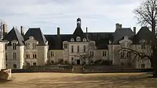
Schloss Marcilly-sur-Maulne
Literatur
- Le Patrimoine des Communes d’Indre-et-Loire. Flohic Editions, Band 1, Paris 2001, ISBN 2-84234-115-5, S. 348–351.
Weblinks
Commons: Marcilly-sur-Maulne – Sammlung von Bildern, Videos und Audiodateien
This article is issued from Wikipedia. The text is licensed under Creative Commons - Attribution - Sharealike. The authors of the article are listed here. Additional terms may apply for the media files, click on images to show image meta data.