Cerelles
Cerelles ist eine französische Gemeinde mit 1.215 Einwohnern (Stand: 1. Januar 2019) im Département Indre-et-Loire in der Region Centre-Val de Loire; sie gehört zum Arrondissement Chinon und zum Kanton Château-Renault (bis 2015: Kanton Neuillé-Pont-Pierre). Die Einwohner werden Cerellois genannt.
| Cerelles | ||
|---|---|---|
| ||
| Staat | Frankreich | |
| Region | Centre-Val de Loire | |
| Département (Nr.) | Indre-et-Loire (37) | |
| Arrondissement | Chinon | |
| Kanton | Château-Renault | |
| Gemeindeverband | Gâtine et Choisilles-Pays de Racan | |
| Koordinaten | 47° 30′ N, 0° 41′ O | |
| Höhe | 62–122 m | |
| Fläche | 12,27 km² | |
| Einwohner | 1.215 (1. Januar 2019) | |
| Bevölkerungsdichte | 99 Einw./km² | |
| Postleitzahl | 37390 | |
| INSEE-Code | 37047 | |
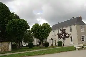 Rathaus (Mairie) von Cerelles | ||

Geographie
Cerelles liegt etwa zwölf Kilometer nördlich von Tours. Umgeben wird Cerelles von den Nachbargemeinden Rouziers-de-Touraine im Norden und Nordwesten, Nouzilly im Osten und Nordosten, Chanceaux-sur-Choisille im Süden sowie Saint-Antoine-du-Rocher im Westen.
Bevölkerungsentwicklung
| Jahr | 1962 | 1968 | 1975 | 1982 | 1990 | 1999 | 2006 | 2013 |
| Einwohner | 392 | 401 | 437 | 575 | 793 | 982 | 1.211 | 1.216 |
| Quelle: Cassini und INSEE | ||||||||
Sehenswürdigkeiten
%252C_l'%C3%A9glise_01.JPG.webp)
Kirche Saint-Pierre
- Kirche Saint-Pierre
- Rathaus, früheres La Grand'Maison von 1641
- Schloss Baudry
- Schloss La Bédouère
- Schloss La Chesnaye
- Herrenhaus Châtenay
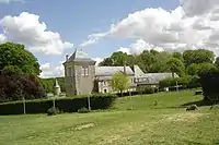 Schloss La Bédouère
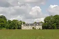 Schloss La Chesnaye
Literatur
- Le Patrimoine des Communes d’Indre-et-Loire. Flohic Editions, Band 2, Paris 2001, ISBN 2-84234-115-5, S. 1016–1018.
Weblinks
Commons: Cerelles – Sammlung von Bildern, Videos und Audiodateien
This article is issued from Wikipedia. The text is licensed under Creative Commons - Attribution - Sharealike. The authors of the article are listed here. Additional terms may apply for the media files, click on images to show image meta data.