Lucenay-lès-Aix
Lucenay-lès-Aix ist eine französische Gemeinde mit 978 Einwohnern (Stand: 1. Januar 2019) im Département Nièvre in der Region Bourgogne-Franche-Comté. Sie gehört zum Arrondissement Nevers und zum Kantons Decize (bis 2015: Kanton Dornes).
| Lucenay-lès-Aix | ||
|---|---|---|

|
| |
| Staat | Frankreich | |
| Region | Bourgogne-Franche-Comté | |
| Département (Nr.) | Nièvre (58) | |
| Arrondissement | Nevers | |
| Kanton | Decize | |
| Gemeindeverband | Sud Nivernais | |
| Koordinaten | 46° 42′ N, 3° 29′ O | |
| Höhe | 202–242 m | |
| Fläche | 55,94 km² | |
| Einwohner | 978 (1. Januar 2019) | |
| Bevölkerungsdichte | 17 Einw./km² | |
| Postleitzahl | 58380 | |
| INSEE-Code | 58146 | |
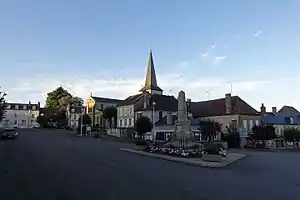 Ortszentrum von Lucenay-lès-Aix | ||

Geographie
Lucenay-lès-Aix liegt etwa 18 Kilometer nordöstlich von Moulins. Umgeben wird Lucenay-lès-Aix von den Nachbargemeinden Cossaye im Norden, Gannay-sur-Loire im Osten, La Chapelle-aux-Chasses im Süden und Südosten, Chézy im Süden, Gennetines im Südwesten, Saint-Ennemond im Westen sowie Toury-Lurcy im Nordwesten.
Bevölkerungsentwicklung
| Jahr | 1962 | 1968 | 1975 | 1982 | 1990 | 1999 | 2006 | 2013 | |
| Einwohner | 1.628 | 1.554 | 1.419 | 1.218 | 1.139 | 1.048 | 1.050 | 1.005 | |
| Quellen: Cassini und INSEE | |||||||||
Sehenswürdigkeiten
- Kirche Saint-Gervais
- Kirche Saint-Genest
- Kirche Saint-Romain
Literatur
- Le Patrimoine des Communes de la Nièvre. Band 1, Flohic Editions, Charenton-le-Pont 1999, ISBN 2-84234-054-X, S. 421–423.
This article is issued from Wikipedia. The text is licensed under Creative Commons - Attribution - Sharealike. The authors of the article are listed here. Additional terms may apply for the media files, click on images to show image meta data.