Louplande
Louplande ist eine französische Gemeinde mit 1.460 Einwohnern (Stand: 1. Januar 2019) im Département Sarthe in der Region Pays de la Loire. Sie gehört zum Arrondissement La Flèche und zum Kanton La Suze-sur-Sarthe. Die Einwohner werden Louplandais genannt.
| Louplande | ||
|---|---|---|
| ||
| Staat | Frankreich | |
| Region | Pays de la Loire | |
| Département (Nr.) | Sarthe (72) | |
| Arrondissement | La Flèche | |
| Kanton | La Suze-sur-Sarthe | |
| Gemeindeverband | Val de Sarthe | |
| Koordinaten | 47° 57′ N, 0° 3′ O | |
| Höhe | 43–102 m | |
| Fläche | 18,45 km² | |
| Einwohner | 1.460 (1. Januar 2019) | |
| Bevölkerungsdichte | 79 Einw./km² | |
| Postleitzahl | 72210 | |
| INSEE-Code | 72169 | |
| Website | http://www.louplande.fr/ | |
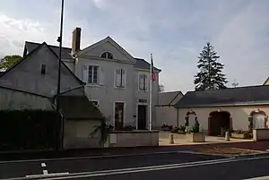 Rathaus (Mairie) von Louplande | ||

Geographie
Louplande liegt etwa 13 Kilometer südwestlich von Le Mans. Umgeben wird Louplande von den Nachbargemeinden Souligné-Flacé im Norden und Nordwesten, Étival-lès-le-Mans im Norden und Osten, Voivres-lès-le-Mans im Süden und Südosten, Roëzé-sur-Sarthe im Süden sowie Chemiré-le-Gaudin im Westen und Südwesten.
Bevölkerungsentwicklung
| Jahr | 1962 | 1968 | 1975 | 1982 | 1990 | 1999 | 2006 | 2013 |
| Einwohner | 676 | 704 | 769 | 914 | 1.137 | 1.193 | 1.448 | 1.482 |
| Quelle: Cassini und INSEE | ||||||||
Sehenswürdigkeiten
- Kirche Saint-Léonard, Ende des 19. Jahrhunderts erbaut
- Schloss Villaines aus dem 17. Jahrhundert, Monument historique seit 1984
 Kirche Louplande
 Schloss Villaines
This article is issued from Wikipedia. The text is licensed under Creative Commons - Attribution - Sharealike. The authors of the article are listed here. Additional terms may apply for the media files, click on images to show image meta data.