Le Sel-de-Bretagne
Le Sel-de-Bretagne, auf Bretonisch Ar Sal, ist eine Gemeinde im französischen Département Ille-et-Vilaine in der Bretagne. Sie gehört zum Arrondissement Redon und grenzt im Norden an Le Petit-Fougeray, im Osten an Saulnières und Tresbœuf, im Süden an La Bosse-de-Bretagne und im Westen an Pancé. Sie war der Hauptort (Chef-lieu) des Kantons Le Sel-de-Bretagne und wurde dann zum Kanton Bain-de-Bretagne geschlagen. Das Siedlungsgebiet liegt ungefähr auf 75 Metern über Meereshöhe. Die Bewohner nennen sich Sellois.
| Le Sel-de-Bretagne | ||
|---|---|---|
| ||
| Staat | Frankreich | |
| Region | Bretagne | |
| Département (Nr.) | Ille-et-Vilaine (35) | |
| Arrondissement | Redon | |
| Kanton | Bain-de-Bretagne | |
| Gemeindeverband | Bretagne Porte de Loire Communauté | |
| Koordinaten | 47° 54′ N, 1° 37′ W | |
| Höhe | 37–107 m | |
| Fläche | 8,57 km² | |
| Einwohner | 1.109 (1. Januar 2019) | |
| Bevölkerungsdichte | 129 Einw./km² | |
| Postleitzahl | 35320 | |
| INSEE-Code | 35322 | |
 Mairie Le Sel-de-Bretagne | ||

Bevölkerungsentwicklung
| Jahr | 1962 | 1968 | 1975 | 1982 | 1990 | 1999 | 2005 | 2017 |
|---|---|---|---|---|---|---|---|---|
| Einwohner | 445 | 456 | 404 | 451 | 501 | 514 | 728 | 1106 |
Sehenswürdigkeiten
- Kirche Saint-Martin
- Kapelle de la Briantais
- Menhire Champ de la Pierre und Champ Horel
- Kriegerdenkmal
Siehe auch: Liste der Monuments historiques in Le Sel-de-Bretagne
 Kirche Saint-Martin
 Chapelle de la Briantais
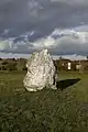 Menhir „Champ Horel“
 Kriegerdenkmal
Literatur
- Le Patrimoine des Communes d’Ille-et-Vilaine. Flohic Editions, Band 2, Paris 2000, ISBN 2-84234-072-8, S. 1625–1630.
Weblinks
Commons: Le Sel-de-Bretagne – Sammlung von Bildern, Videos und Audiodateien
This article is issued from Wikipedia. The text is licensed under Creative Commons - Attribution - Sharealike. The authors of the article are listed here. Additional terms may apply for the media files, click on images to show image meta data.