Loutehel
Loutehel ist eine Gemeinde in der Bretagne in Frankreich. Sie gehört zum Département Ille-et-Vilaine, zum Arrondissement Redon und zum Kanton Guichen. Sie grenzt im Nordwesten an Plélan-le-Grand, im Norden an Maxent, im Westen und im Süden an Maure-de-Bretagne und im Westen an Guer. Das Siedlungsgebiet liegt ungefähr auf 50 Metern über Meereshöhe.
| Loutehel | ||
|---|---|---|
| ||
| Staat | Frankreich | |
| Region | Bretagne | |
| Département (Nr.) | Ille-et-Vilaine (35) | |
| Arrondissement | Redon | |
| Kanton | Guichen | |
| Gemeindeverband | Vallons de Haute-Bretagne Communauté | |
| Koordinaten | 47° 56′ N, 2° 5′ W | |
| Höhe | 31–99 m | |
| Fläche | 7,25 km² | |
| Einwohner | 247 (1. Januar 2019) | |
| Bevölkerungsdichte | 34 Einw./km² | |
| Postleitzahl | 35330 | |
| INSEE-Code | 35160 | |

Bevölkerungsentwicklung
| Jahr | 1962 | 1968 | 1975 | 1982 | 1990 | 1999 | 2008 | 2013 |
|---|---|---|---|---|---|---|---|---|
| Einwohner | 247 | 234 | 197 | 196 | 223 | 191 | 208 | 246 |
Sehenswürdigkeiten
- Kirche Saint-Armel
- Château de la Lohière
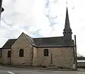 Kirche Saint-Armel
 Château de la Lohière, Aufnahme aus dem Jahr 1910
Literatur
- Le Patrimoine des Communes d’Ille-et-Vilaine. Flohic Editions, Band 2, Paris 2000, ISBN 2-84234-072-8, S. 922–925.
Weblinks
Commons: Loutehel – Sammlung von Bildern, Videos und Audiodateien
This article is issued from Wikipedia. The text is licensed under Creative Commons - Attribution - Sharealike. The authors of the article are listed here. Additional terms may apply for the media files, click on images to show image meta data.