Le Castéra
Le Castéra ist eine französische Gemeinde mit 718 Einwohnern (Stand 1. Januar 2019) im Département Haute-Garonne in der Region Okzitanien. Sie gehört zum Arrondissement Toulouse und zum Kanton Léguevin.
| Le Castéra | ||
|---|---|---|
.svg.png.webp)
|
| |
| Staat | Frankreich | |
| Region | Okzitanien | |
| Département (Nr.) | Haute-Garonne (31) | |
| Arrondissement | Toulouse | |
| Kanton | Léguevin | |
| Gemeindeverband | Save Garonne et Coteaux de Cadours | |
| Koordinaten | 43° 40′ N, 1° 8′ O | |
| Höhe | 125–284 m | |
| Fläche | 16,82 km² | |
| Einwohner | 718 (1. Januar 2019) | |
| Bevölkerungsdichte | 43 Einw./km² | |
| Postleitzahl | 31530 | |
| INSEE-Code | 31120 | |
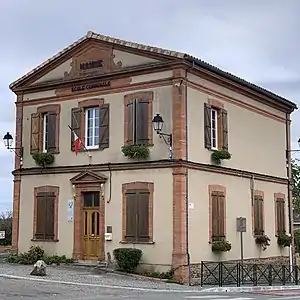 Mairie Le Castéra | ||

Geographie
Le Castéra liegt im Süden Frankreichs. Nördlich der Gemeinde liegt Thil, östlich Menville, südlich Pradère-les-Bourguets und westlich von ihr die Gemeinde Bellegarde-Sainte-Marie.
Bevölkerungsentwicklung
| Jahr | 1962 | 1968 | 1975 | 1982 | 1990 | 1999 | 2008 | 2017 |
| Einwohner | 282 | 322 | 305 | 395 | 455 | 597 | 746 | 736 |
Sehenswürdigkeiten
- Kirche Saint-Eutrope
- Kirche Saint-Jean-Baptiste
- Kapelle Saint-Symphorien
Siehe auch: Liste der Monuments historiques in Le Castéra
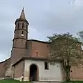 Kirche Saint-Eutrope
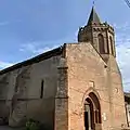 Kirche Saint-Jean-Baptiste
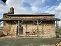 Kapelle Saint-Symphorien
Literatur
- Le Patrimoine des Communes de la Haute-Garonne. Flohic Editions, Band 1, Paris 2000, ISBN 2-84234-081-7, S. 412–414.
Weblinks
Commons: Le Castéra – Sammlung von Bildern, Videos und Audiodateien
This article is issued from Wikipedia. The text is licensed under Creative Commons - Attribution - Sharealike. The authors of the article are listed here. Additional terms may apply for the media files, click on images to show image meta data.