Flourens
Flourens (okzitanisch: Florenç) ist eine französische Gemeinde mit 2.056 Einwohnern (Stand: 1. Januar 2019) im Département Haute-Garonne in der Region Okzitanien. Sie gehört zum Arrondissement Toulouse und zum Kanton Toulouse-10 (bis 2015: Kanton Toulouse-8). Die Einwohner werden Flourensois genannt.
| Flourens Florenç | ||
|---|---|---|
| ||
| Staat | Frankreich | |
| Region | Okzitanien | |
| Département (Nr.) | Haute-Garonne (31) | |
| Arrondissement | Toulouse | |
| Kanton | Toulouse-10 | |
| Gemeindeverband | Toulouse Métropole | |
| Koordinaten | 43° 36′ N, 1° 34′ O | |
| Höhe | 152–243 m | |
| Fläche | 9,71 km² | |
| Einwohner | 2.056 (1. Januar 2019) | |
| Bevölkerungsdichte | 212 Einw./km² | |
| Postleitzahl | 31130 | |
| INSEE-Code | 31184 | |
| Website | https://www.flourens.fr | |
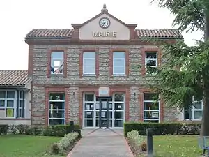 Rathaus von Flourens | ||

Geografie
Flourens liegt etwa neun Kilometer östlich von Toulouse. Der Fluss Seillonne begrenzt die Gemeinde im Nordosten. Umgeben wird Flourens von den Nachbargemeinden Pin-Balma im Norden und Nordwesten, Mons im Norden und Nordosten, Drémil-Lafage im Süden und Osten, Quint-Fonsegrives im Süden und Südwesten sowie Balma im Westen.
Durch den Süden und am südöstlichen Rand der Gemeinde führt die frühere Route nationale 126 (heutige D826).
Bevölkerungsentwicklung
| Jahr | Einwohner |
|---|---|
| 1962 | 348 |
| 1968 | 424 |
| 1975 | 592 |
| 1982 | 930 |
| 1990 | 1506 |
| 1999 | 1793 |
| 2006 | 1706 |
| 2017 | 1963 |
Sehenswürdigkeiten
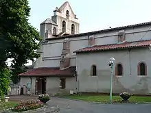
Kirche Saint-Martin
- Kirche Saint-Martin
Literatur
- Le Patrimoine des Communes de la Haute-Garonne. Flohic Editions, Band 2, Paris 2000, ISBN 2-84234-081-7, S. 1510–1512.
Weblinks
Commons: Flourens (Haute-Garonne) – Sammlung von Bildern, Videos und Audiodateien
This article is issued from Wikipedia. The text is licensed under Creative Commons - Attribution - Sharealike. The authors of the article are listed here. Additional terms may apply for the media files, click on images to show image meta data.