Gauré
Gauré (okzitanisch Gaure) ist eine französische Gemeinde im Département Haute-Garonne in der Region Okzitanien. Sie gehört zum Arrondissement Toulouse und zum Kanton Pechbonnieu (bis 2015: Kanton Verfeil). Die 467 Einwohner (Stand: 1. Januar 2019) werden Gauréens genannt.
| Gauré Gaure | ||
|---|---|---|
.svg.png.webp)
|
| |
| Staat | Frankreich | |
| Region | Okzitanien | |
| Département (Nr.) | Haute-Garonne (31) | |
| Arrondissement | Toulouse | |
| Kanton | Pechbonnieu | |
| Gemeindeverband | Coteaux du Girou | |
| Koordinaten | 43° 37′ N, 1° 38′ O | |
| Höhe | 164–243 m | |
| Fläche | 13,50 km² | |
| Einwohner | 467 (1. Januar 2019) | |
| Bevölkerungsdichte | 35 Einw./km² | |
| Postleitzahl | 31590 | |
| INSEE-Code | 31215 | |
| Website | http://www.gaure.net/ | |
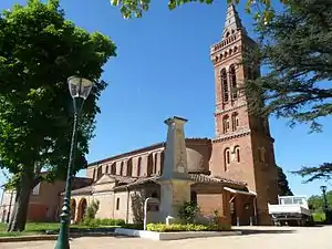 Kirche Saint-Julien | ||

Geographie
Gauré liegt etwa 14 Kilometer östlich von Toulouse. Umgeben wird Gauré von den Nachbargemeinden Saint-Pierre im Norden, Verfeil im Nordosten, Bourg-Saint-Bernard im Osten, Vallesvilles im Süden, Drémil-Lafage im Westen und Südwesten sowie Lavalette im Westen und Nordwesten.
Bevölkerungsentwicklung
| Jahr | 1962 | 1968 | 1975 | 1982 | 1990 | 1999 | 2006 | 2017 |
| Einwohner | 305 | 252 | 270 | 319 | 355 | 495 | 492 | 494 |
| Quellen: Cassini und INSEE | ||||||||
Sehenswürdigkeiten
- Kirche Saint-Julien
Literatur
- Le Patrimoine des Communes de la Haute-Garonne. Flohic Editions, Band 2, Paris 2000, ISBN 2-84234-081-7, S. 1684–1685.
Weblinks
Commons: Gauré – Sammlung von Bildern, Videos und Audiodateien
This article is issued from Wikipedia. The text is licensed under Creative Commons - Attribution - Sharealike. The authors of the article are listed here. Additional terms may apply for the media files, click on images to show image meta data.