Kanton Wassy
Der Kanton Wassy ist ein französischer Wahlkreis im Arrondissement Saint-Dizier, im Département Haute-Marne und in der Region Grand Est; sein Hauptort ist Wassy.
| Kanton Wassy | |
|---|---|
| Region | Grand Est |
| Département | Haute-Marne |
| Arrondissement | Saint-Dizier |
| Hauptort | Wassy |
| Einwohner | 11.085 (1. Jan. 2019) |
| Bevölkerungsdichte | 31 Einw./km² |
| Fläche | 353,63 km² |
| Gemeinden | 20 |
| INSEE-Code | 5217 |
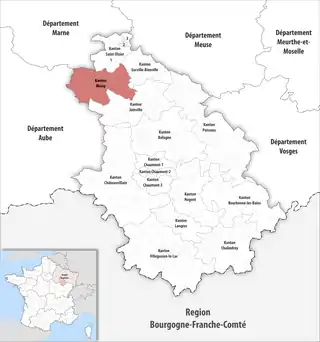 Lage des Kantons Wassy im Département Haute-Marne | |
Der Kanton Wassy ist 348,14 km² groß und hat 11.085 Einwohner (Stand: 2019), was einer Bevölkerungsdichte von 32 Einwohnern pro km² entspricht. Er liegt im Mittel 193 m hoch.
Gemeinden
Der Kanton besteht aus 20 Gemeinden mit insgesamt 11.085 Einwohnern (Stand: 1. Januar 2019) auf einer Gesamtfläche von 353,63 km²:
| Gemeinde | Einwohner 1. Januar 2019 |
Fläche km² |
Dichte Einw./km² |
Code INSEE |
Postleitzahl |
|---|---|---|---|---|---|
| Attancourt | 267 | 12,36 | 22 | 52021 | 52130 |
| Bailly-aux-Forges | 143 | 10,68 | 13 | 52034 | 52130 |
| Brousseval | 659 | 5,99 | 110 | 52079 | 52130 |
| Ceffonds | 645 | 36,59 | 18 | 52088 | 52220 |
| Dommartin-le-Franc | 243 | 9,98 | 24 | 52171 | 52130 |
| Doulevant-le-Petit | 20 | 2,98 | 7 | 52179 | 52130 |
| Frampas | 154 | 10,31 | 15 | 52206 | 52220 |
| La Porte du Der | 2.282 | 47,45 | 48 | 52331 | 52220 |
| Laneuville-à-Rémy | 66 | 5,95 | 11 | 52266 | 52220 |
| Montreuil-sur-Blaise | 147 | 1,41 | 104 | 52336 | 52130 |
| Morancourt | 131 | 14,05 | 9 | 52341 | 52130 |
| Planrupt | 306 | 8,39 | 36 | 52391 | 52220 |
| Rachecourt-Suzémont | 106 | 3,64 | 29 | 52413 | 52130 |
| Rives Dervoises | 1.329 | 78,23 | 17 | 52411 | 52220 |
| Sommevoire | 664 | 33,03 | 20 | 52479 | 52220 |
| Thilleux | 70 | 9,74 | 7 | 52487 | 52220 |
| Vaux-sur-Blaise | 372 | 7,11 | 52 | 52510 | 52130 |
| Ville-en-Blaisois | 146 | 6,94 | 21 | 52528 | 52130 |
| Voillecomte | 516 | 14,46 | 36 | 52543 | 52130 |
| Wassy | 2.819 | 34,34 | 82 | 52550 | 52130 |
| Kanton Wassy | 11.085 | 353,63 | 31 | 5217 | – |
Bis zur landesweiten Neuordnung der Kantone 2015 bestand der Kanton Wassy aus den 20 Gemeinden Allichamps, Attancourt, Bailly-aux-Forges, Brousseval, Domblain, Dommartin-le-Franc, Doulevant-le-Petit, Fays, Louvemont, Magneux, Montreuil-sur-Blaise, Morancourt, Rachecourt-Suzémont, Sommancourt, Troisfontaines-la-Ville, Valleret, Vaux-sur-Blaise, Ville-en-Blaisois, Voillecomte und Wassy (Hauptort). Sein Zuschnitt entsprach einer Fläche von 209,99 km2. Er besaß vor 2015 einen anderen INSEE-Code als heute, nämlich 5228.
Veränderungen im Gemeindebestand seit der landesweiten Neuordnung der Kantone
2016
- Fusion Montier-en-Der und Robert-Magny → La Porte du Der
- Fusion Droyes, Longeville-sur-la-Laines, Louze und Puellemontier → Rives Dervoises