Valleret
Valleret ist eine französische Gemeinde mit 65 Einwohnern (Stand 1. Januar 2019) im Département Haute-Marne in der Region Grand Est. Sie gehört zum Arrondissement Saint-Dizier und zum Kanton Eurville-Bienville.
| Valleret | ||
|---|---|---|
| ||
| Staat | Frankreich | |
| Region | Grand Est | |
| Département (Nr.) | Haute-Marne (52) | |
| Arrondissement | Saint-Dizier | |
| Kanton | Eurville-Bienville | |
| Gemeindeverband | Saint-Dizier, Der et Blaise | |
| Koordinaten | 48° 29′ N, 5° 0′ O | |
| Höhe | 183–263 m | |
| Fläche | 4,80 km² | |
| Einwohner | 65 (1. Januar 2019) | |
| Bevölkerungsdichte | 14 Einw./km² | |
| Postleitzahl | 52130 | |
| INSEE-Code | 52502 | |

Geografie
Die Gemeinde Valleret liegt etwa 15 Kilometer südlich von Saint-Dizier. Durch den Westen des Gemeindegebietes fließr die Blaise. Valleret ist umgeben von folgenden Nachbargemeinden:
| Wassy | Magneux | Sommancourt |
| Brousseval | .svg.png.webp) |
Maizières |
| Vaux-sur-Blaise | Domblain | Fays |
Bevölkerungsentwicklung
| Jahr | 1962 | 1968 | 1975 | 1982 | 1990 | 1999 | 2008 | 2019 |
|---|---|---|---|---|---|---|---|---|
| Einwohner | 90 | 83 | 64 | 66 | 69 | 67 | 50 | 65 |
| Quellen: Cassini und INSEE | ||||||||
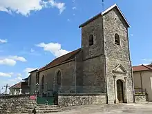
Kirche Saint-Lumier in Valleret
Weblinks
Commons: Valleret – Sammlung von Bildern, Videos und Audiodateien
This article is issued from Wikipedia. The text is licensed under Creative Commons - Attribution - Sharealike. The authors of the article are listed here. Additional terms may apply for the media files, click on images to show image meta data.