Attancourt
Attancourt ist eine französische Gemeinde mit 267 Einwohnern (Stand 1. Januar 2019) im Département Haute-Marne in der Region Grand Est. Sie gehört zum Kanton Wassy und zum Arrondissement Saint-Dizier.
| Attancourt | ||
|---|---|---|
| ||
| Staat | Frankreich | |
| Region | Grand Est | |
| Département (Nr.) | Haute-Marne (52) | |
| Arrondissement | Saint-Dizier | |
| Kanton | Wassy | |
| Gemeindeverband | Saint-Dizier, Der et Blaise | |
| Koordinaten | 48° 32′ N, 4° 56′ O | |
| Höhe | 149–211 m | |
| Fläche | 12,36 km² | |
| Einwohner | 267 (1. Januar 2019) | |
| Bevölkerungsdichte | 22 Einw./km² | |
| Postleitzahl | 52130 | |
| INSEE-Code | 52021 | |

Geografie
Die Gemeinde Attancourt liegt an der Blaise, elf Kilometer südlich von Saint-Dizier und acht Kilometer südöstlich des größten französischen Stausees Lac du Der-Chantecoq. Sie ist umgeben von folgenden Nachbargemeinden:
| Allichamps | Humbécourt | Troisfontaines-la-Ville |
| Louvemont | .svg.png.webp) |
|
| Wassy | Magneux |
Bevölkerungsentwicklung
| Jahr | 1962 | 1968 | 1975 | 1982 | 1990 | 1999 | 2008 | 2018 | |
|---|---|---|---|---|---|---|---|---|---|
| Einwohner | 210 | 208 | 195 | 307 | 278 | 241 | 242 | 266 | |
| Quellen: Cassini und INSEE | |||||||||
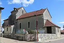
Kirche Saint-Louvent
Weblinks
Commons: Attancourt – Sammlung von Bildern, Videos und Audiodateien
This article is issued from Wikipedia. The text is licensed under Creative Commons - Attribution - Sharealike. The authors of the article are listed here. Additional terms may apply for the media files, click on images to show image meta data.