Germay
Germay ist eine französische Gemeinde mit 48 Einwohnern (Stand: 1. Januar 2019) im Département Haute-Marne in der Region Grand Est. Die Gemeinde gehört zum Arrondissement Saint-Dizier und zum Kanton Poissons.
| Germay | ||
|---|---|---|
| ||
| Staat | Frankreich | |
| Region | Grand Est | |
| Département (Nr.) | Haute-Marne (52) | |
| Arrondissement | Saint-Dizier | |
| Kanton | Poissons | |
| Gemeindeverband | Bassin de Joinville en Champagne | |
| Koordinaten | 48° 25′ N, 5° 21′ O | |
| Höhe | 319–427 m | |
| Fläche | 11,97 km² | |
| Einwohner | 48 (1. Januar 2019) | |
| Bevölkerungsdichte | 4 Einw./km² | |
| Postleitzahl | 52230 | |
| INSEE-Code | 52218 | |
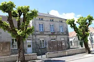 Rathaus (Mairie) von Germay | ||

Geografie
Germay liegt etwa 38 Kilometer südöstlich von Saint-Dizier. Die Saulx entspringt in der Gemeinde. Umgeben wird Germay von den Nachbargemeinden Thonnance-les-Moulins im Norden und Westen, Lezéville im Norden und Osten, Grand und Morionvilliers im Südosten, Germisay im Süden sowie Épizon im Süden und Südwesten.
Bevölkerungsentwicklung
| Jahr | 1962 | 1968 | 1975 | 1982 | 1990 | 1999 | 2006 | 2011 | 2018 |
|---|---|---|---|---|---|---|---|---|---|
| Einwohner | 80 | 77 | 72 | 81 | 67 | 61 | 46 | 46 | 47 |
| Quellen: Cassini und INSEE | |||||||||
Sehenswürdigkeiten
- Kirche Saint-Evre
- Waschhaus
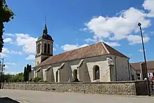
Kirche Saint-Evre
Weblinks
Commons: Germay – Sammlung von Bildern, Videos und Audiodateien
This article is issued from Wikipedia. The text is licensed under Creative Commons - Attribution - Sharealike. The authors of the article are listed here. Additional terms may apply for the media files, click on images to show image meta data.