Beurville
Beurville ist eine französische Gemeinde mit 103 Einwohnern (Stand: 1. Januar 2019) im Département Haute-Marne in der Region Grand Est. Sie gehört zum Kanton Joinville und zum Arrondissement Saint-Dizier.
| Beurville | ||
|---|---|---|

|
| |
| Staat | Frankreich | |
| Region | Grand Est | |
| Département (Nr.) | Haute-Marne (52) | |
| Arrondissement | Saint-Dizier | |
| Kanton | Joinville | |
| Gemeindeverband | Bassin de Joinville en Champagne | |
| Koordinaten | 48° 19′ N, 4° 50′ O | |
| Höhe | 200–336 m | |
| Fläche | 23,03 km² | |
| Einwohner | 103 (1. Januar 2019) | |
| Bevölkerungsdichte | 4 Einw./km² | |
| Postleitzahl | 52110 | |
| INSEE-Code | 52047 | |

Geografie
Die Gemeinde Beurville liegt 25 Kilometer südlich des größten französischen Stausees Lac du Der-Chantecoq an der Grenze zum Département Aube. Sie ist umgeben von folgenden Nachbargemeinden:
| Nully, Thil | Blumeray | Cirey-sur-Blaise |
| Thors | .svg.png.webp) |
Bouzancourt |
| Saulcy | Rizaucourt-Buchey | Daillancourt |
Bevölkerungsentwicklung
| Jahr | 1962 | 1968 | 1975 | 1982 | 1990 | 1999 | 2008 | 2018 |
|---|---|---|---|---|---|---|---|---|
| Einwohner | 216 | 182 | 175 | 150 | 138 | 111 | 103 | 104 |
| Quellen: Cassini und INSEE | ||||||||
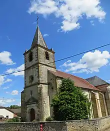
Kirche Saint-Étienne
Weblinks
Commons: Beurville – Sammlung von Bildern, Videos und Audiodateien
This article is issued from Wikipedia. The text is licensed under Creative Commons - Attribution - Sharealike. The authors of the article are listed here. Additional terms may apply for the media files, click on images to show image meta data.