Artemps
Artemps ist eine französische Gemeinde mit 367 Einwohnern (Stand 1. Januar 2019) im Département Aisne in der Region Hauts-de-France (vor 2016 Picardie). Sie gehört zum Arrondissement Saint-Quentin, zum Kanton Ribemont und zum Gemeindeverband Saint-Quentinois.
| Artemps | ||
|---|---|---|
| ||
| Staat | Frankreich | |
| Region | Hauts-de-France | |
| Département (Nr.) | Aisne (02) | |
| Arrondissement | Saint-Quentin | |
| Kanton | Ribemont | |
| Gemeindeverband | Saint-Quentinois | |
| Koordinaten | 49° 46′ N, 3° 11′ O | |
| Höhe | 62–93 m | |
| Fläche | 6,34 km² | |
| Einwohner | 367 (1. Januar 2019) | |
| Bevölkerungsdichte | 58 Einw./km² | |
| Postleitzahl | 02480 | |
| INSEE-Code | 02025 | |
_mairie-%C3%A9cole.JPG.webp) Rathaus (Mairie) und Schule von Artemps | ||

Geografie
Das Dorf Artemps liegt am linken Ufer der Somme sowie am Kanal von Saint-Quentin nordwestlich von Laon und südlich von Saint-Quentin. Umgeben wird Artemps von den Nachbargemeinden Tugny-et-Pont im Westen, Happencourt im Nordwesten, Seraucourt-le-Grand im Nordosten, Clastres im Südwesten sowie Saint-Simon im Süden.
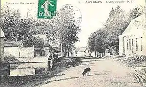 Alte Ansicht der Straße am Kanal
_pont_du_Canal_de_Saint-Quentin.JPG.webp) Brücke am Kanal von Saint-Quentin
Brücke am Kanal von Saint-Quentin
Bevölkerungsentwicklung
| Jahr | 1962 | 1968 | 1975 | 1982 | 1990 | 1999 | 2007 | 2018 |
| Einwohner | 264 | 289 | 292 | 297 | 347 | 338 | 356 | 369 |
| Quellen: Cassini und INSEE | ||||||||
Sehenswürdigkeiten
- Kirche Saint-Martin
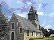
Kirche Saint-Martin
This article is issued from Wikipedia. The text is licensed under Creative Commons - Attribution - Sharealike. The authors of the article are listed here. Additional terms may apply for the media files, click on images to show image meta data.