Annois
Annois ist eine französische Gemeinde mit 362 Einwohnern (Stand 1. Januar 2019) im Département Aisne in der Region Hauts-de-France (vor 2016 Picardie). Sie gehört zum Arrondissement Saint-Quentin, zum Kanton Ribemont und zum Gemeindeverband Saint-Quentinois.
| Annois | ||
|---|---|---|
| ||
| Staat | Frankreich | |
| Region | Hauts-de-France | |
| Département (Nr.) | Aisne (02) | |
| Arrondissement | Saint-Quentin | |
| Kanton | Ribemont | |
| Gemeindeverband | Saint-Quentinois | |
| Koordinaten | 49° 43′ N, 3° 11′ O | |
| Höhe | 63–158 m | |
| Fläche | 5,99 km² | |
| Einwohner | 362 (1. Januar 2019) | |
| Bevölkerungsdichte | 60 Einw./km² | |
| Postleitzahl | 02480 | |
| INSEE-Code | 02019 | |
_mairie.JPG.webp) Rathaus (Mairie) von Annois | ||

Geografie
Die Gemeinde Annois liegt am Canal de Saint-Quentin, 15 Kilometer südwestlich der Stadt Saint-Quentin. Umgeben wird Annois von den Nachbargemeinden Saint-Simon im Norden, Flavy-le-Martel im Osten, La Neuville-en-Beine im Süden, Cugny im Westen sowie Ollezy im Nordwesten.
Bevölkerungsentwicklung
| Jahr | 1962 | 1968 | 1975 | 1982 | 1990 | 1999 | 2006 | 2019 |
| Einwohner | 358 | 345 | 370 | 397 | 372 | 383 | 375 | 362 |
| Quellen: Cassini und INSEE | ||||||||
Sehenswürdigkeiten
- Kirche Saint-Martin
- Britischer Militärfriedhof der Commonwealth War Graves Commission
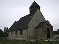 Kirche Saint-Martin
_cimeti%C3%A8re%252C_CWCG_graves_(01).JPG.webp) Kriegsgräber der CWCG
Kriegsgräber der CWCG
This article is issued from Wikipedia. The text is licensed under Creative Commons - Attribution - Sharealike. The authors of the article are listed here. Additional terms may apply for the media files, click on images to show image meta data.