Villiers-Fossard
| Villiers-Fossard | ||
|---|---|---|
.svg.png.webp)
|
| |
| Staat | Frankreich | |
| Region | Normandie | |
| Département (Nr.) | Manche (50) | |
| Arrondissement | Saint-Lô | |
| Kanton | Pont-Hébert | |
| Gemeindeverband | Saint-Lô Agglo | |
| Koordinaten | 49° 9′ N, 1° 4′ W | |
| Höhe | 20–133 m | |
| Fläche | 8,80 km² | |
| Einwohner | 657 (1. Januar 2019) | |
| Bevölkerungsdichte | 75 Einw./km² | |
| Postleitzahl | 50680 | |
| INSEE-Code | 50641 | |
| Website | http://damien.rauline.pagesperso-orange.fr/villiers.htm | |

Villiers-Fossard ist eine französische Gemeinde mit 657 Einwohnern (Stand: 1. Januar 2019) im Département Manche in der Region Normandie. Die Gemeinde gehört zum Kanton Pont-Hébert im Arrondissement Saint-Lô. Die Einwohner werden Villariens genannt.
Geographie
Villiers-Fossard liegt etwa fünf Kilometer nordnordöstlich von Saint-Lô. Umgeben wird Villiers-Fossard von den Nachbargemeinden Saint-Clair-sur-l’Elle im Norden, Couvains im Osten, La Luzerne im Südosten, Le Mesnil-Rouxelin im Süden sowie La Meauffe im Westen.
Einwohnerentwicklung[1]
| 1962 | 1968 | 1975 | 1982 | 1990 | 1999 | 2006 | 2018 |
| 445 | 376 | 354 | 417 | 417 | 465 | 509 | 650 |
Kultur und Sehenswürdigkeiten
- Kirche Saint-Pierre aus dem 11. Jahrhundert
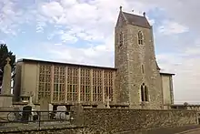
Kirche Saint-Pierre
Weblinks
Commons: Villiers-Fossard – Sammlung von Bildern, Videos und Audiodateien
This article is issued from Wikipedia. The text is licensed under Creative Commons - Attribution - Sharealike. The authors of the article are listed here. Additional terms may apply for the media files, click on images to show image meta data.