Villeny
Villeny ist eine französische Gemeinde mit 484 Einwohnern (Stand: 1. Januar 2019) im Département Loir-et-Cher in der Region Centre-Val de Loire; sie gehört zum Arrondissement Romorantin-Lanthenay und zum Kanton Chambord (bis 2015: Kanton Neung-sur-Beuvron).
| Villeny | ||
|---|---|---|
| ||
| Staat | Frankreich | |
| Region | Centre-Val de Loire | |
| Département (Nr.) | Loir-et-Cher (41) | |
| Arrondissement | Romorantin-Lanthenay | |
| Kanton | Chambord | |
| Gemeindeverband | Sologne des Étangs | |
| Koordinaten | 47° 37′ N, 1° 45′ O | |
| Höhe | 93–136 m | |
| Fläche | 35,48 km² | |
| Einwohner | 484 (1. Januar 2019) | |
| Bevölkerungsdichte | 14 Einw./km² | |
| Postleitzahl | 41220 | |
| INSEE-Code | 41285 | |
| Website | http://www.villeny.com/ | |
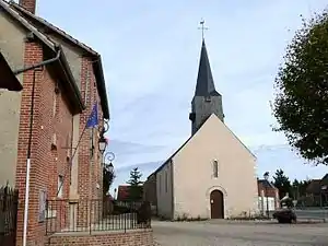 Kirche Saint-Martin und Rathaus (Mairie) von Villeny | ||

Geographie
Villeny liegt etwa 22 Kilometer ostnordöstlich von Blois in der Sologne. Umgeben wird Villeny von den Nachbargemeinden Ligny-le-Ribault im Norden, Yvoy-le-Marron im Osten, La Marolle-en-Sologne im Süden und Südosten, Montrieux-en-Sologne im Süden, Dhuizon im Westen und Südwesten sowie La Ferté-Saint-Cyr im Westen und Nordwesten.
Bevölkerungsentwicklung
| Jahr | 1962 | 1968 | 1975 | 1982 | 1990 | 1999 | 2006 | 2017 |
| Einwohner | 488 | 461 | 381 | 336 | 324 | 334 | 358 | 493 |
| Quellen: Cassini und INSEE | ||||||||
Sehenswürdigkeiten
- Kirche Saint-Martin
This article is issued from Wikipedia. The text is licensed under Creative Commons - Attribution - Sharealike. The authors of the article are listed here. Additional terms may apply for the media files, click on images to show image meta data.