Saint-Viâtre
Saint-Viâtre ist eine französische Gemeinde mit 1.180 Einwohnern (Stand: 1. Januar 2019) im Département Loir-et-Cher in der Region Centre-Val de Loire; sie gehört zum Arrondissement Romorantin-Lanthenay und zum Kanton La Sologne (bis 2015: Kanton Salbris).
| Saint-Viâtre | ||
|---|---|---|
.svg.png.webp)
|
| |
| Staat | Frankreich | |
| Region | Centre-Val de Loire | |
| Département (Nr.) | Loir-et-Cher (41) | |
| Arrondissement | Romorantin-Lanthenay | |
| Kanton | La Sologne | |
| Gemeindeverband | Sologne des Étangs | |
| Koordinaten | 47° 31′ N, 1° 56′ O | |
| Höhe | 92–132 m | |
| Fläche | 99,53 km² | |
| Einwohner | 1.180 (1. Januar 2019) | |
| Bevölkerungsdichte | 12 Einw./km² | |
| Postleitzahl | 41210 | |
| INSEE-Code | 41231 | |
| Website | http://www.saint-viatre.fr/ | |

Geographie
Saint-Viâtre liegt etwa 55 Kilometer nordwestlich von Bourges. Umgeben wird Saint-Viâtre von den Nachbargemeinden Chaumont-sur-Tharonne im Norden, Nouan-le-Fuzelier im Osten, Salbris im Südosten, La Ferté-Imbault im Süden, Marcilly-en-Gault im Südwesten sowie Neung-sur-Beuvron und La Ferté-Beauharnais im Nordwesten.
Etwa 10 % der Gemeindefläche wird von Teichen und Seen bedeckt.
Bevölkerungsentwicklung
| Jahr | 1962 | 1968 | 1975 | 1982 | 1990 | 1999 | 2006 | 2017 |
| Einwohner | 1282 | 1245 | 1223 | 1162 | 1063 | 1157 | 1188 | 1196 |
| Quellen: Cassini und INSEE | ||||||||
Sehenswürdigkeiten
- Kirche Saint-Viâtre
- Ökomuseum der Sologne
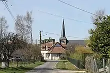
Kirche Saint-Viâtre
Weblinks
Commons: Saint-Viâtre – Sammlung von Bildern, Videos und Audiodateien
This article is issued from Wikipedia. The text is licensed under Creative Commons - Attribution - Sharealike. The authors of the article are listed here. Additional terms may apply for the media files, click on images to show image meta data.