Loreux
Loreux ist eine Gemeinde mit 200 Einwohnern (Stand: 1. Januar 2019) im französischen Département Loir-et-Cher der Region Centre-Val de Loire. Die Gemeinde gehört zum Arrondissement Romorantin-Lanthenay und zum Kanton Romorantin-Lanthenay (bis 2015: Kanton Romorantin-Lanthenay-Sud).
| Loreux | ||
|---|---|---|
| ||
| Staat | Frankreich | |
| Region | Centre-Val de Loire | |
| Département (Nr.) | Loir-et-Cher (41) | |
| Arrondissement | Romorantin-Lanthenay | |
| Kanton | Romorantin-Lanthenay | |
| Gemeindeverband | Romorantinais et du Monestois | |
| Koordinaten | 47° 24′ N, 1° 50′ O | |
| Höhe | 88–124 m | |
| Fläche | 32,15 km² | |
| Einwohner | 200 (1. Januar 2019) | |
| Bevölkerungsdichte | 6 Einw./km² | |
| Postleitzahl | 41200 | |
| INSEE-Code | 41118 | |

Geographie
Loreux liegt etwa 43 Kilometer südöstlich von Blois und etwa acht Kilometer nordöstlich vom Stadtzentrum von Romorantin-Lanthenay in der Sologne. Umgeben wird Loreux von den Nachbargemeinden Millançay im Norden und Westen, Marcilly-en-Gault im Norden und Nordosten, Selles-Saint-Denis im Osten sowie Villeherviers im Süden und Westen.
Bevölkerungsentwicklung
| 1962 | 1968 | 1975 | 1982 | 1990 | 1999 | 2006 | 2017 |
|---|---|---|---|---|---|---|---|
| 339 | 285 | 247 | 260 | 265 | 255 | 248 | 209 |
| Quellen: Cassini und INSEE | |||||||
Sehenswürdigkeiten
- Kirche Saint-Laurian
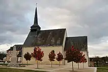
Kirche Saint-Laurian
Weblinks
Commons: Loreux – Sammlung von Bildern, Videos und Audiodateien
This article is issued from Wikipedia. The text is licensed under Creative Commons - Attribution - Sharealike. The authors of the article are listed here. Additional terms may apply for the media files, click on images to show image meta data.